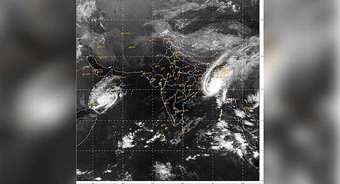
NEW DELHI: Cyclone Hamoon has significantly intensified in the Bay of Bengal and is expected to make landfall in Bangladesh on October 25. Beginning as a ‘deep depression’, it has now evolved into a ‘very severe cyclone’. The Hamoon’s strength is being fuelled by higher sea surface temperatures, which will likely rise as it progresses.
The cyclone’s impact is not limited to Bangladesh; it has also disrupted the Northeast monsoon in southern India. The consequences of Hamoon’s presence include heavy rainfall in Northeastern states like Nagaland, Manipur, Tripura and Mizoram. Coastal regions of West Bengal, Odisha coast, eastern Bihar and Jharkhand can expect light to moderate rainfall.
Currently, Hamoon is situated over the Northwest Bay of Bengal, moving northeastward at a speed of 17 kmph. As it nears the coast south of Chittagong in Bangladesh, it is expected to weaken somewhat, becoming a ‘cyclonic storm’ with wind speeds of 80-90 kmph, gusting up to 100 kmph. A storm surge of approximately 1-1.5 metres above the astronomical tide is projected, which may inundate low-lying areas between Khepupara and Chittagong. Nevertheless, Bangladesh is not anticipated to face severe impacts.
Furthermore, cyclone Hamoon has delayed the onset of the Northeast monsoon by an additional four days, which has significant implications for Tamil Nadu, particularly in terms of winter crops, drinking water and industrial use. In the Arabian Sea, cyclonic storm ‘Tej’ has weakened into a deep depression over Yemen, with its speed reducing to 9 km per hour.
According to the IMD forecast, Northwestern Indian states including Punjab, Haryana, Rajasthan, Delhi and Uttar Pradesh can expect normal and dry weather conditions over the next seven days. While minimum temperatures will gradually decrease, the region has recently experienced lower temperatures due to a series of western disturbances, marking an early onset of winter.
Effect on monsoon
Cyclone Hamoon has delayed the onset of the Northeast monsoon by an additional four days, which has significant implications for Tamil Nadu, particularly in terms of winter crops, drinking water and industrial use.