VISAKHAPATNAM: Parts of costal Andhra Pradesh received rainfall under the influence the depression brewing over Bay of Bengal that moved from the northwestward towards Bangladesh on Friday. Visakhapatnam received brief spells of showers in some areas on Thursday.
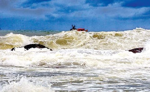
On Friday, the sea remained rough as squally wind blew across the day, which mostly remained cloudy.
High tides lashed the shore dangerously near the fishing harbour. The community guards have been told to remain alert and see that no one entered the beach.
According to duty officer of the Cyclone Warning Centre, Visakhapatnam, the depression was positioned 240 km South-east of Visakhapatnam and 490 km southwest of Paradeep in Odisha. It is likely to move northwards and could weaken gradually towards Bangladesh coast. In Srikakulam district, many areas received rains associated with strong winds. Polaki received 80.2 mm of rain, the highest in the district, followed by Mandasa (67.2 mm), Sompeta (55.2 mm) and Tekkali (34.2 mm), with the average being put at 18.2 mm.
However, agriculture authorities said that the ongoing spells of rain would hardly affect the paddy crop, with the harvesting likely to begin in a few weeks. Farmers need not to worry unless the fields get waterlogged as the crop is in milking and grain filling stage, said quality control (agriculture) officer Ajay.
However, CWC officials said rains were expected at several places across the costal Andhra Pradesh, with heavy shower at a few places. Winds with speed of 45-55 kmph are expected and fishermen are advised not to venture out into the sea, they said.
According to the India Meteorological Department (IMD), the system would reach Bangladesh coast in the next 48 hours. Before reaching the coast, it is likely to intensify into a deep depression and subsequently a cyclonic storm, which will be named Nada as suggested by Oman.
The weatherman said that the system would likely to make a landfall at Khepupara in Bangladesh.