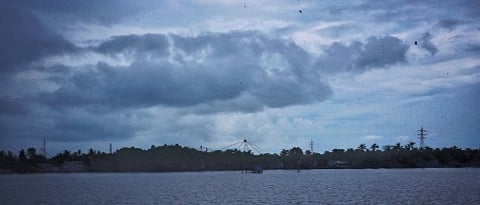
KOCHI: Mango showers or monsoon rains? This has been puzzling weather watchers as it pours in Kerala, much to the elation of rain romancers and irritation of those stuck on waterlogged roads.
Despite the heavy showers, the India Meteorological Department, the principal national agency for weather forecasting and seismology, has not yet declared the advent of the southwest monsoon.
Why? Well, let’s first look at the ‘what’ part
The southwest monsoon is the most important weather event of the Indian subcontinent. The rain system that sets in Kerala and then gradually passes over the entire country, reaching Kashmir in about 45 days, is responsible for about 80 per cent of rainfall of the region.
Once upon a time, it was thought that this massive rain event – which, like clockwork, arrives in this small coastal state around the first week of June – was the result of differential seasonal heating and cooling of land and ocean, resulting in land and sea breezes on mammoth scales.
However, this theory put forward by British astronomer Edmund Halley in 1686 was found insufficient in explaining this extraordinary weather phenomenon.
Then came the dynamic theory proposed by Hermann Flohn, a German climatologist, that connected the seasonal migration of planetary winds and pressure belts. This one, too, did not hold for long.
Thereon, explanations have been ever-evolving. “The latest theory considers the Tibetan Plateau, jet streams, oceanic water circulation, El Niño and La Niña and southern oscillations, upper air circulation, and more,” explains Jamshad K, MD of Metbeat Weather, a private weather firm based in Kozhikode.

Next, the ‘how’ bit
The southwest monsoon is a trade wind. Its formation, flow, and direction all depend on the Sun’s position — the annual march of the star.
Seasonally, the Sun is in the northern hemisphere around this time, where it’s summer. Winter is about to begin in the southern hemisphere. That means the southern hemisphere with low temperatures is feeling high pressure and the north a low pressure. The wind flows from the high-pressure area to the low-pressure one.
“As the wind starts flowing towards the north, it reaches a high-pressure zone near the Mascarene Islands — a semi-permanent high pressure system called Mascarene High — in the Indian Ocean,” says M G Manoj, a scientist with Cusat’s Advanced Centre for Atmospheric Radar Research.
“Crossing this area, the wind reaches the equator. As it begins to cross the equator, thanks to the Coriolis force formed due to Earth’s rotation, the wind changes course. And that’s how it reaches Kerala.”
Due to the Coriolis force, the wind direction further shifts to the right as it crosses the equator. “So by the time it reaches Kerala, we feel the wind is coming in from the southwest direction,” Manoj adds.
“The wind, carrying clouds from the seas, first lands on islands such as Andaman and Nicobar Islands, Sri Lanka, and Maldives, and, finally, reaches Kerala.”
Jamshad notes that the Tibetan Plateau will be warmer during summer. “Thus, a low-pressure is formed over that region, and this helps the monsoon winds move across India,” he says.
“Jet streams also play an important role. These are fast-flowing, meandering air currents on the atmosphere’s upper level. They help the monsoon spread to the other parts of India. In 45 days, the monsoon reaches Srinagar. The last point is Rajasthan. Then it moves over Pakistan.”
The return journey
With the rains, the northern hemisphere cools. With this, the Indian region forms a high-pressure zone. And the oceans, with a relatively slow progression to colder temperatures, provide a low-pressure zone.
“So now, the process repeats in the opposite direction, with colder wind flowing from the land to the sea — this is what we call the retreating monsoon, or Thulavarsham in Kerala,” says Jamsahad.
So, has the monsoon arrived?
“This is the transition from pre-monsoon to monsoon,” says Manoj. He adds that there are some criteria for declaring the onset of monsoon. They are:
Rainfall: Monsoon observation begins on May 10. About 60 per cent of the 14 stations in south India should report rainfall of 2.5mm or more for two consecutive days. “Currently, Kerala is witnessing just that. Then, the onset will be declared on the second day, provided other criteria are also met,” explains Manoj.
Wind field: The depth of westerlies, or the southwest monsoon wind, should acquire a stipulated depth, at least 4km from the ground up. “As of now, this criterion has not been met,” Manoj notes.
Outgoing Longwave Radiation (OLR): “Everything releases infrared rays – be it animals, humans, or clouds,” he says. “Radiations measured by the Indian National Satellite System (INSAT) should be below 200 watts per square metre. That means clouds should be ‘cold’.”
As the depth of the clouds is larger, the upper parts will be very cold. That is why, during monsoon, even after the rains stop, the atmosphere doesn’t turn warm immediately, unlike the case of summer showers.
What’s El Niño, La Niña, IOD?
The El Niño and La Niña are climate patterns that form over the Pacific Ocean. They cause unusual warming and cooling of the oceanic waters, affecting global climatic patterns. El Niño, which means ‘little boy’ in Spanish, causes unusual warming of surface waters in the eastern Pacific Ocean, and it is known to weaken the Indian monsoon. La Niña, the ‘little girl’, is called a ‘cold event’, strengthens the monsoon. During periods of La Niña, trade winds (normal surface winds) tend to intensify. “Right now, the El Niño is weakening. By June, La Niña will be in play,” says Jamshad.The Indian Ocean Dipole (IOD) is a similar weather event that occurs over the Indian Ocean. A positive IOD year means a stronger monsoon.
Monsoon
The word monsoon originates from the Arabic word ‘mausim’, which means season. The term was originally used in British India to describe the powerful seasonal winds that brought rain from the Indian Ocean.
Cloudburst
Cloudbursts are characterised by an intense burst of rain in a short period and over a limited area (75mm or above per hour). Cloudbursts usually occur when a monsoon cloud drifts northwards from the Bay of Bengal or Arabian Sea across the plains, then onto the Himalayas.
Mango showers
During summer, the land heats faster than the water and creates low-pressure conditions on the land. As a result, air rises and slowly loses heat, and goes on to form cumulonimbus clouds. The rain from these clouds are called pre-monsoon/summer/mango showers. They occur between March and June in Kerala.
Jetstreams
A healthy monsoon season relies on a stable jet stream pattern that allows the moist winds to blow consistently over India. Jetstreams are relatively narrow bands of strong wind in the upper levels of the atmosphere. Their position affects the arrival time, strength, and spread of monsoon rains.
IMD update
“The conditions continue to look favourable for monsoon onset in Kerala over the next 24 hours. By Thursday morning, we will get an update from Delhi,” says an IMD official.