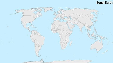

World maps can be seen as instruments through which dominant powers exercise their influence. That is why the United Nations’ decision last week to adopt the Equal Earth projection is a significant move, reflecting a global history stretching back more than four centuries—and right up to the present moment. This tumultuous history owes as much to Flemish geographer Gerardus Mercator’s way of projecting a round world in two dimensions as it does to high-stakes espionage carried out in Goa.
In the era in which European navigators adopted Mercator’s idea—the projection the UN vote has now retired—sailing maps were keys to trading treasures. Portuguese merchants, who enjoyed a near-monopoly over Asia’s spice trade with Europe in the 16th century, closely guarded their maps, which helped them navigate the Indian Ocean. It was only when Dutch merchant Jan Huyghen van Linschoten, who served as private secretary to the Archbishop of Goa in the 1580s, surreptitiously copied these maps and published them in Europe in the 1590s that the colonial era was effectively flung open. The information, coupled with Mercator’s projection published a few decades earlier, made sailing easier for transcontinental merchants.
The biggest consequence of last week’s change is that equatorial nations, which appeared much smaller on the Mercator projection, will be represented more equitably. Consider the oddity of having seen Africa as barely bigger than Greenland on maps, though the continent can fit 14 Greenlands within it, with room to spare. As the foreign minister of Togo, the nation that proposed the UN resolution, explained: “There is scientific proof, so we all have to accept the reality.”
India, one of the 164 nations backing the resolution, later clarified that no new map can deny India’s sovereign claim over lands in Jammu and Kashmir. The vote and the clarification underline the political implications of modern cartography. Like most African nations, India is acutely aware of the danger that unratified maps pose in legitimising expansionist claims. It reminds us that disagreements with China over the lines drawn in Ladakh, Sikkim and Arunachal Pradesh cannot be allowed to morph into alternative realities about sovereignty over those regions.
It was telling that the US was the only nation to oppose the UN resolution. The stance reflected Donald Trump’s worldview, in which all it apparently takes to rechristen the Gulf of Mexico, Lake Ontario and even the US state of New Mexico is a broad-nibbed pen. Even in the era of Google Maps, such transgressions cannot be allowed to stand.
