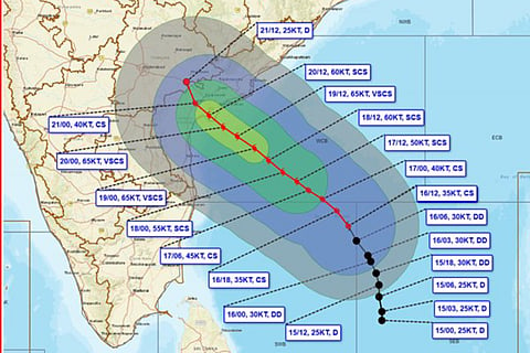

Cyclonic Storm 'Akvan' over the Bay of Bengal is likely to intensify into a severe cyclonic storm by Tuesday evening and further strengthen into a very severe cyclonic storm by November 19 morning, the India Meteorological Department (IMD) said on Monday.
In its latest update, the weather department said the storm lay over the central parts of the south and adjoining west-central Bay of Bengal at 5.30 pm on November 16, about 610 km east of Chennai.
Akvan is likely to move west-northwestwards and cross the Andhra Pradesh and Yanam coasts between Nellore and Tuni around noon on November 20 as a very severe cyclonic storm, with maximum sustained wind speeds of 120-130 kmph and gusts reaching 145 kmph.
The developing system marks the third cyclone to threaten the Andhra Pradesh coast in about three weeks, following severe cyclonic storms Arnab and Murasu. The successive weather systems have put Andhra Pradesh on alert, with the IMD warning of heavy to extremely heavy rainfall in several coastal districts as Akvan approaches.
The IMD has also issued a pre-cyclone watch for the Andhra Pradesh and adjoining south Odisha coasts. The storm's movement and intensity are being closely monitored as it approaches the eastern coastline.
