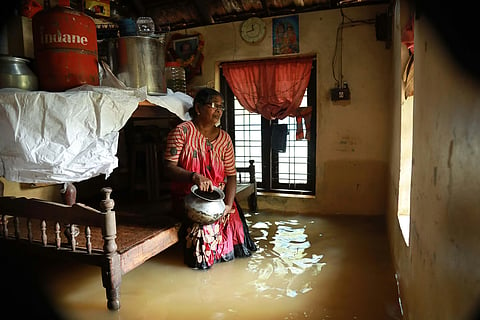

We live in an era when changing rainfall patterns, floods, landslides, heat waves and other extreme climatic events are no longer rare. As the devastation in Nepal—soon after deadly floods in Kerala and Assam—showed, we must urgently adapt to live with climate change.
Yet, an important distinction must be made: rain itself is not a disaster. Disaster results from the interaction of natural hazards with vulnerable landscapes, inappropriate land use, inadequate scientific understanding, weak early-warning systems and delayed decisions.
Kerala—where heavy monsoon rainfall is a natural feature—is particularly exposed as it is marked by densely-packed valleys and extensive development along slopes and floodplains. Intense, short rainfall can rapidly saturate the slopes, overwhelm drainage systems and transform streams into destructive torrents. Landslides occur when rainfall-induced saturation combines with geological structure, soil thickness, weathering, slope geometry, drainage and land-use conditions to destabilise slopes.
The problem is aggravated when wetlands are reclaimed, drainage channels obstructed, floodplains encroached upon and hill slopes modified for roads, buildings, plantations and infrastructure. Such interventions reduce the natural capacity of the landscape to absorb, store and safely convey water.
Kerala's 41 west-flowing rivers are generally short and steep, resulting in rapid hydrological responses during extreme rainfall. Flood risk, therefore, increases when river channels, floodplains and wetlands are prevented from performing their natural functions.
The devastating floods of 2018 had demonstrated the complex interaction between extreme rainfall, catchment conditions, reservoir storage and dam operations. Kerala should undertake independent scientific assessments of reservoir operations and flood management practices. Dam operating rules, reservoir storage, flood cushion and downstream risks must be reassessed under changing climatic conditions. Reservoir sedimentation also requires continuous assessment because loss of storage capacity can affect flood management.
Controlled desiltation may be appropriate in selected reservoirs after rigorous engineering and environmental assessment. However, indiscriminate dredging of natural rivers should be avoided. Groundwater deserves equal attention.
Rivers are dynamic, physical, hydrogeological and ecological systems, not merely drainage channels. Scientific mapping of aquifer hydrodynamics, protection of recharge zones and conservation of riverbeds and wetlands should become integral components of water-resource management.
Kerala's highlands require stronger scientific understanding of slope stability. Rainfall is only one trigger among several interacting factors. Geological structure, soil properties, weathering, slope geometry, drainage, vegetation and land-use changes determine susceptibility.
The disasters at Kavalappara and Puthumala in 2019, Pettimudi in 2020, Kokkayar and Koottickal in 2021, and Mundakkai-Chooralmala in 2024 demonstrate the devastating consequences of slope instability.
Not just Kerala, several Indian states urgently need high-resolution landslide-hazard mapping, continuous slope monitoring, detailed geological investigations and scientifically-established rainfall thresholds. Research must directly influence land-use decisions, road construction, quarrying regulations, building permissions and evacuation plans.
Mountain soils require extremely long geological and biological processes to form; their loss through erosion and landslides therefore cannot be quickly restored.
India's forecasting, Doppler radar, satellite observation, lightning detection, automated weather stations and numerical modelling capabilities have improved considerably. The real test begins after a warning is issued. An effective system must establish a clear chain: forecast followed by hazard assessment, decision-making, warning signal, evacuation, rescue and, finally, recovery.
A warning has little value if vulnerable families are not evacuated, dangerous roads remain open or downstream communities uninformed about rising reservoir levels. It must reach fishermen at sea, farmers, travellers, residents beneath unstable slopes and families living near rivers. Messages should be location-specific, simple and actionable.
The lesson from Assam
Assam provides an important parallel. The state has repeatedly suffered devastating floods, riverbank erosion and landslides, causing substantial loss of life and property. Last month’s severe events, which have claimed over 100 lives, illustrate its continuing vulnerability.
The state’s geological and geomorphological setting is fundamental to understanding this risk. The tectonically-active Himalayan region, the mighty Brahmaputra and its highly braided channel system create conditions conducive to recurrent flooding and erosion. The river transports enormous quantities of sand, silt and clay derived from the easily erodible tertiary formations of the young Himalaya.
Extreme rainfall and high-sediment loads can alter channel morphology, intensify bank erosion and reduce effective flood-carrying capacity across extensive floodplains. The 1950 earthquake, estimated at around 8.6 magnitude, further demonstrates the region's intense tectonic activity. It triggered numerous landslides and introduced enormous sediment quantities into river systems, producing long-term geomorphological changes.
Flood and landslide management in Assam, therefore, cannot depend primarily on emergency response and relief. It requires integrated river-basin management, sediment monitoring, floodplain regulation, landslide-risk assessment and improved early-warning systems. Quarrying, deforestation and other activities that destabilise slopes and drainage systems must be strictly regulated. Large-scale ecological restoration and afforestation are particularly important in vulnerable catchments.
Both Kerala and Assam demonstrate that India needs disaster-risk management models tailored to regional, geological, geomorphological, hydrological and climatic conditions. Kerala requires a model suited to the Western Ghats, short rivers, densely-settled valleys, coastal environment and changing monsoon. Assam requires one that recognises the dynamic Brahmaputra system, enormous sediment loads, active tectonics, Himalayan catchments and extensively braided floodplains.
Both states should prioritise comprehensive district-level climate and disaster-risk mapping; scientific floodplain and landslide-hazard zoning; climate-responsive revision of dam and reservoir operating rules; continuous monitoring of reservoir sedimentation and storage capacity; real-time monitoring of rainfall, rivers, reservoirs and vulnerable slopes; state-wide landslide early-warning and slope-monitoring systems; effective coastal, lightning and seismic warning systems; protection of wetlands, river corridors and groundwater-recharge areas; integrated river-basin and sediment-management programmes; strict regulation of quarrying, deforestation and destabilising land-use practices; ecological restoration and afforestation of vulnerable catchments; and clear institutional responsibility for converting warnings into timely action.
Real disaster is failure to act
Kerala cannot control the monsoon, cloudbursts or landslides. Assam cannot control the Brahmaputra, Himalayan sediment influx, extreme rainfall or tectonic processes. But both states can control how intelligently they prepare for them.
Rain is natural; flood disasters are not always. A landslide may be triggered by rainfall, but vulnerability can be created or intensified by human intervention. Scientific warnings save lives only when institutions act upon them in time.
The central challenge is therefore not to fight nature, but to understand and respect natural processes and regulate human activities accordingly. Every warning must lead to action. Every scientific finding must influence policy. Every disaster must generate institutional learning.
Kerala and Assam represent different landscapes facing a common challenge. Yet both demonstrate the same fundamental truth: when natural hazards interact with poorly planned human intervention, vulnerability increases and disasters become more destructive.
India must, therefore, move decisively from a culture of disaster response to a culture of disaster prevention and management.
Rain will continue to fall. Rivers will continue to flow. Mountains will continue to evolve. The real question is whether we understand these processes well enough—and act early enough—to protect people and ecosystems from avoidable disasters.
V Nandakumar | Retired Head, Natural Hazards Research Group and Director, National Centre for Earth Science Studies, Thiruvananthapuram
(Views are personal)
