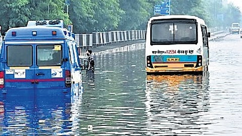
NEW DELHI: Ahead of the monsoon season, the Delhi government has identified 169 locations across the Capital that are prone to waterlogging. Of these, around 31 hotspots are located along the Ring Road, according to the Delhi government’s recently-published flood control order, which lists 169 locations where persistent waterlogging was observed in 2025.
Nine underpasses have been flagged as particularly vulnerable, including Minto Bridge, Zakhira, Dwarka, Moolchand & Pul Prahlad Pur underpasses managed by the Public Works Department (PWD), and Ram Bagh, Okhla, Sarita Vihar &Pandav Nagar underpasses maintained by other departments.
“To prevent flooding in these areas, the PWD has installed temporary pump sets and issued a standard operating procedure for managing water accumulation, especially in underpasses,” the order read. Besides, a total of 445 waterlogging hotspots have been mapped based on traffic police data from 2023, 2024 and 2025 and are currently under close monitoring, officials said.
Among waterlogging hotspots in and around the ITO crossing, authorities have identified areas adjoining Delhi Secretariat and the Indira Gandhi Indoor Stadium, where persistent flooding has been observed. Other areas include stretches near the PWD headquarters, opposite to the old police headquarters, Rajghat crossing, Bahadur Shah Zafar Marg, and near the Indraprastha metro station.
The Mathura Road link to the main Pragati Maidan tunnel and the entrance from the Purana Qila road has also been identified as a waterlogging hotspot by the PWD. The area has been prone to episodes of flooding on several occasions in past years, hampering traffic movement in the area.
With respect to the Yamuna water levels, the first warning shall be issued by the central flood control room as soon as the discharge from Hathni Kund Barrage exceeds one lakh cusecs. Subsequently, relevant sector control rooms shall start functioning and keep vigil in respective areas. For flood monitoring the warning level is 204.50 metres, the danger level is 205.33 metres and the evacuation level is 206 metres, the flood control order states.
To avoid urban flooding, the government plans to operate 11 regulator drains to regulate water discharge into the Yamuna. To gauge the flood situation in the Yamuna, the Old Railway Bridge has been identified as the reference for water level.
The regulators constructed at mouths of drains opening into the Yamuna will be operated from time to time to suitably pump out the city drainage. In case the river is in high flood due to heavy rainfall, locally or upstream, the regulator gates would remain closed to prevent backflow of water into the city, the order states.
Testing the waters
Nine underpasses have been flagged as particularly vulnerable
These include Minto Bridge, Moolchand and Okhla underpasses
Temporary pump sets installed and SOP issued for water accumulation
445 waterlogging hotspots have been mapped based on traffic police data
Rajghat crossing & Bahadur Shah Zafar Marg, among hotspots identified
11 drains to control outflow into the Yamuna
