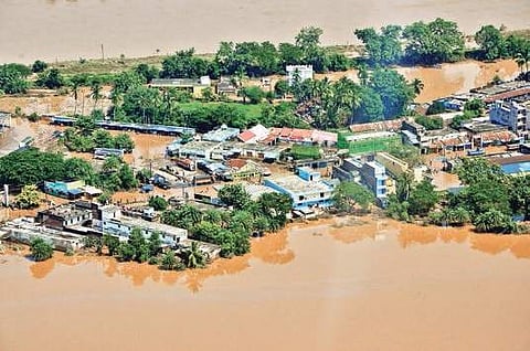
BHUBANESWAR: As a fresh spell of rain is likely to lash Odisha during next three days due to formation of a low pressure area in the Bay of Bengal, the State Government on Monday asked the district collectors to remain on high alert to tackle a possible flood situation.
In an advisory issued to the collectors, Special Relief Commissioner (SRC) Bishnupada Sethi has requested them to keep the administrative machinery prepared to meet any situation that may arise in the event of intense rainfall. “Areas vulnerable to flood/waterlogging may be identified in advance and field officials should remain prepared to evacuate people from vulnerable locations to safe shelters if required,” he said.
The advisory said advance arrangements may be made for providing adequate food, safe drinking water, lighting, health and sanitation facilities at all shelters/relief camps. The SRC has asked the collectors to the intimate requirement of ODRAF team if any.
Fire services teams have also been asked to remain prepared to carry out search and rescue operation. Officials of the departments concerned have been told to remain prepared for taking up immediate restoration works. Besides, the SRC said necessary arrangements should be made to restrict people/vehicles from using the roads/bridges under submergence.
According to the meteorological centre, the low-pressure area over northwest Bay of Bengal and the adjoining West Bengal and Bangladesh coasts may trigger light to moderate rain or thundershower in most parts of the State. Heavy to very heavy rain is expected in next 24 hours in north coastal Odisha and some areas in the western and the northern parts of the State, including Mayurbhanj, Sonepur, Keonjhar, Balangir, Bargarh, Kalahandi, Kandhamal, Raygada, Nayagarh and Puri districts. Similarly, extremely heavy rainfall is likely to batter parts of Bhadrak, Kendrapada, Jagatsinghpur, Kandhamal, Rayagada and Kalahandi.
The MeT centre has forecast heavy to very heavy rainfall on Tuesday and Wednesday in parts of south interior Odisha and districts such as Sundargarh, Jharsuguda, Sambalpur and Bargarh. Heavy rainfall is also likely at isolated places over Mayurbhanj, Keonjhar, Gajapati, Ganjam, Nayagarh, Khordha, Puri, Jajpur, Jagatsinghpur, Angul and Dhenkanal during this period. Squally weather with wind speed exceeding 45 kmph is likely with sea condition being rough to very rough along and off the Odisha coast and northwest Bay of Bengal and adjoining Westcentral Bay of Bengal. Fishermen have been advised against venturing into the sea in the next 48 hours.
Menwhile, Kandhamal district received 41.7 mm rainfall, followed by Balangir 33.1 mm, Balasore 23.3 mm, Jharsuguda 21.9 mm and Bhadrak 20.5 mm in the last 24 hours. Titlagarh recorded 98 mm rainfall till 5.30 pm, followed by 64 mm at Sonepur and 50 mm at Cuttack.
