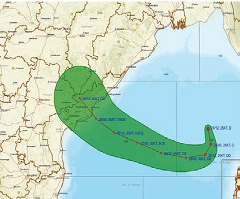

BHUBANESWAR: The cyclone building over the Bay of Bengal may just spare Odisha as the storm is likely to skirt the state and approach the Andhra Pradesh coast between Bapatla and Visakhapatnam, the India Meteorological Department (IMD) indicated in its latest forecast on Saturday.
As per the national forecaster, Friday’s low-pressure intensified into a well-marked low-pressure area over east-central and adjoining southeast Bay of Bengal on the day. It then strengthened into a depression later in the evening. The system is expected to move west-northwestwards, intensify further into a deep depression on Sunday and into a cyclonic storm over west-central Bay of Bengal on Monday morning.
Moving west-northwestwards, it will continue to intensify further and reach over the west-central Bay of Bengal near Andhra Pradesh coast around Wednesday morning, said the IMD. The latest status said it was centred about 1,100 km east of Bapatla.
As it crosses the Yanam coast between Bapatla and Visakhapatnam, it would gather power as a very severe cyclonic storm with the maximum sustained wind speed of 115-125 kmph gusting to 140 kmph by October 28.
Some weather agencies, meanwhile, suggested rapid intensification of the system. As per the Joint Typhoon Warning Centre (JTWC), environmental analysis indicates a favourable area for development of the storm.
“Global deterministic and ensemble models are in agreement of formation of the storm within 24 hours and a reversal in its motion towards the west. The potential for the development of a significant tropical cyclone within the next 24 hours is high,” it added.
Though the cyclone’s exact landfall location is yet to be ascertained, Odisha is expected to receive very heavy rains between Tuesday and Thursday under its influence.
The regional met office has issued warning for heavy to very heavy rainfall in Jagatsinghpur, Rayagada, Koraput, Malkangiri, Gajapati, Ganjam and Puri districts on Tuesday. Rayagada, Koraput, Malkangiri, Gajapati and Ganjam districts may experience extremely heavy rainfall, while heavy to very heavy rainfall is likely to occur in 17 districts, mostly in coastal and interior regions of the state on Wednesday.
The cyclone is expected to trigger squally weather conditions with wind speed reaching 40 kmph to 50 kmph and gusting up to 60 kmph along and off Odisha coast on Tuesday and Wednesday. The regional met office has cautioned that the storm may cause damage to power and communication lines.
