THOOTHUKUDI: Activists and experts now bank on the Shoreline Management Plans (SMP) recommended recently by the National Green Tribunal (NGT) order to restore the disfigured coastline of Tamil Nadu. This is because only 37% of the coast remains stable while the rest has either faced erosion or accretion. They have also welcomed the recent National Green Tribunal order on the construction of hard structures.
Tamil Nadu coastline
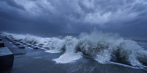
The State has 13 coastal districts and the coastline is dissected by prominent rivers such as Cauvery, Palar, Vaigai, and Thamirabarani. There are varying geomorphic features such as beaches, silts, sand dunes, lagoons, estuaries, beach ridges, and rocky coasts along the 991 km-long coastline. Both natural phenomenons and human interventions, in the form of artificial and hard structures, play a major role in shaping the coastline.
According to the National Assessment of Shoreline Changes, a status report from 1990 to 2016 released by the Ministry of Earth Sciences and National Centre for Coastal Research (NCCR), about 40% of the Tamil Nadu coastline had been eroded, 23% had been accreted and only 37% of the coast remains undisturbed. The report attributed these changes to the manmade structures on the seashore.
Speaking to TNIE, NCCR Director Dr MV Ramana Murthy, one of the three authors of the report, said the impact of the manmade structures along the coast, sediment movements, and the vulnerable areas of erosion need to be studied as part of the shoreline management plan.
Murthy further said another major factor for erosion and accretion along the coastline is the reduction of sediment supply from the rivers to the sea and added that the deficiency of sediment transportation leads to erosion.
With the changing climatic scenario like sea-level rise, rapid cyclones, and high waves, being witnessed in the last decade, the author said a reassessment of the design of the structures is required to mitigate the cascading effects on the adjacent areas.
The scientist added, “The mitigation plans should not cause an impact on the adjacent areas and need a scientific approach. These aspects should be considered while designing these structures coming up on shoreline management plans.”
Issue and solution
Environment activist Nitiyanand Jeyaraman said the construction of groynes, seawalls, boat jetty, minor ports, and harbours along the coast over the years have caused serious geomorphological changes along the coastline. He added that the Intergovernmental Panel of Climatic Change had termed it as "maladaptation".
The NGT had recently ordered to halt construction of groynes along the seashore in order to pursue further research. Welcoming the order, Nitiyanand said the State government should immediately devise a shoreline management plan and ensure its proper implementation to mitigate damages to the coastline.
An international research organisation's earth observation expert Raj Bhagat Palanichamy told TNIE that enormous construction of check dams, anaicuts, and other water obstruction structures without proper impact assessment on the river courses have restricted the sediment supply to the estuaries, from where the sediment is transported in accordance to the wind and wave patterns.
Pertaining to Tamil Nadu coastline, the longshore drift triggered by the wind directions prevails from south to north between March and October, and blows in the reverse direction during northeast monsoon season between November and February, he explained. Palanichamy said the sediment transportation prevails from south to north predominantly, and when the sediment supply reduces, it causes erosion.
Tamil Nadu has a number of East flowing rivers, whose sediment supply to the sea course had stopped in the past two decades owing to the construction of check dams and anaicuts without proper sand vent facilities, he pointed out.
The river ecosystem has been mishandled with the lone idea of harnessing water for human consumption, instead of efficient management plans to ensure the hydrological cycle is completed, the expert observed.
What does the report say?
The district-level status report on Erosion-Stable-Accretion shows that the coastal length of Kancheepuram, Villupuram, Tiruvarur and Kanniyakumari have been dominated by erosion, while the more than 50% of the coastline of Tirunelveli and Thoothukudi districts are subjected accretion.
Tamil Nadu coastline - 991.47 km
High erosion - 14.66 km
Moderate erosion - 36.65 km
Low erosion - 355.74 km
Low accretion - 194.27 km
Moderate accretion - 23.96 km
High accretion - 12.63 km
Unalterated - 353.74 km
The four southern districts — Ramanathapuram, Thoothukudi, Tirunelveli and Kanniyakumari — constitute a 514.2 km long coastline accounting for 52% of Tamil Nadu's coastline have been subjected to severe geomorphological changes in the past three decades.
Ramanathapuram coast stretch - 272.01 km
Erosion - 104.3 km
Accretion - 41.77 km
Remains stable - 125.95 km
Thoothukudi coast stretch - 121.43 km
Erosion - 21.8 km
Accretion - 52.64 km.
Tirunelveli coast stretch - 51.70 km
Erosion - 9.40 km
Accretion - 20.7 km
Kanniyakumari coastline stretch - 69.06 km
Erosion - 44.56 km
Accretion - 6.64 km