THOOTHUKUDI: As World Environment Day, 2022, focuses on 'living sustainably in harmony with nature', experts have appealed to the State government to recognise and conserve the centuries-old man-made water network system - kulam - of Thamirabarani river course.
Adapting the traditional knowledge of water management could play a critical role in climate resilience at this juncture of climate change debates, they noted.
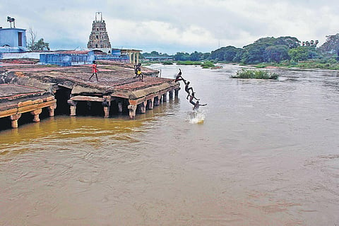
Thamirabarani originates from a peak of "Podhigai" about 1,867 metre above the mean seal level, and runs for 125 kilometre down the semi-arid landscape of Tirunelveli and Thoothukudi districts before merging into Gulf of Mannar at Punnakayal here.
It irrigates over 86,287 acre of aycut land through 11 channels branching off from eight anaicuts, called as water diverting structures. The eight anaicuts intersecting the river course are Kodaimel Azhagian, Nathiyunni, Kannadian, Ariyanayakipuram, Pazhavoor, Suthamalli, Marudur and Srivaikuntam.
According to literary sources, the Pandiyan kings and Nayakas had built the seven anaicuts, whereas the last Srivaikuntam anaicut, was built by the British between 1856 to 1873. The ancient seven anaicuts have special engineering features with the alignment of "inverted L" to branch out one channel, and "inverted U" to take off two channels.
The Marudur anaicut, the longest of all anaicuts, built in the 13th century, is in the shape of a horse shoe. Thamirabarani feeds 187 irrigation tanks in Tirunelveli and 53 in Thoothukudi, said sources.
These irrigation tanks are the man-made kulams connected by the canals to draw water from the anaicuts built across the river. The local folklores, temple rituals along the ghats, and the living traditions exhibit the intangible heritage of a Kulam.
Human settlements are formed along kulams, and the names of the village are eponymous with tanks, and moreover they have associated rituals.
London-based conservation architect Saranya Dharshini, who researched cultural landscape of the Thamirabarani, told The New Indian Express that the Thamirabarani river course has a phenomenon of recurring flood and droughts and hence kulams structures were built along the north and south banks of the river.
Crediting the idea of harnessing flood waters at kulams to the Pandyan kingdom that ruled the region (4 BCE - 14 BCE), Saranya said "It is a climate-adaptive mechanism which needs to be adapted even now for climate resilience".
The Pandyas had converted the dry lands into wetland ecosystems by diverting the flood waters into kulams, and the wetland concept is indigenous to the Thamirabarani region, she argued.
Each kulams gets filled by the natural geographical pattern as the river course traverses down the slope from the several metres high mountains of the Western Ghats to the low-lying Gulf of Mannar in the eastern end.
The kulams have been a judicious plan to store waters in variable climatic conditions, as the Thamirabarani landscape being a rain-shadow region receives poor rain during southwest monsoon and high rainfall coupled by storm and cyclones during the northeast monsoon, she said.
Stating that this ancient water management model has been the mainstay of the region still, catering water to the hundreds of acres of agricultural lands, Saranya appealed to the state to recognise the traditional kulam water network as the water management was schematic even before the arrival of the British. "This perspective will build confidence in local communities and learning from the past would be appropriate to adapt strategies for the changing climatic conditions," she said.
ATREE's Senior Research Associate M Mathivanan, who assisted the wetland study in Thamirabarani region, said that the ancient settlers were adept at tackling the climatic changes and thus they had dug tanks to store flood waters and had promoted irrigation. The traditional knowledge has aided preservation of the wetland until the last century, but it needs to be taken forward.
"So due recognition for the existing archaic water management principles and conservation efforts are required for longer sustainability, as rapid urbanisation has detached the people's connectivity with the environment and water bodies, '' he added.
Folklore writer Muthalankurichi Kamarasu said that sastha temples, known as ancestral worship, are widely found on the Kulam's bank. The folklore songs clearly reveal their connectivity to the monsoonal and summer rains for irrigating kar and pesanam crops. The folklore songs had now faded away with the invention of televisions, he added.
Saranya also pointed to the disappearance of the stone madais (sluices), an ancient installation to cater water for irrigation, and the stone ghats, which profess the long heritage of each kulams. "The heritage elements of the water bodies such as Neerazhikal, which denote the flood level, are being replaced by metal sluices," she contended.
