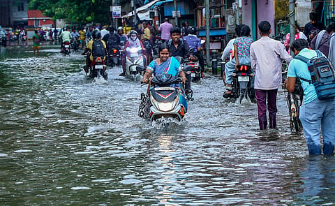

A low-pressure area formed over the Southwest Bay of Bengal on Wednesday, prompting the India Meteorological Department (IMD) to forecast heavy to very heavy rainfall across parts of Tamil Nadu over the next two days, as torrential overnight showers uprooted trees and inundated low-lying areas in Chennai and other parts of the state.
The low-pressure area formed at 5.30 am on October 21 under the influence of an upper-air cyclonic circulation over the Southwest Bay of Bengal off the Tamil Nadu coast, and persisted over the same region at 8.30 am, according to the IMD's Regional Meteorological Centre. The associated cyclonic circulation extends up to 5.8 km above mean sea level.
Heavy to very heavy rain is likely at isolated places on Thursday, accompanied by thunderstorms, lightning and gusty winds reaching 40-50 kmph at one or two places. Tuticorin, Tirunelveli, Kanyakumari, Tenkasi, Virudhunagar, Ramanathapuram, Theni, Dindigul, Madurai, Coimbatore, the Nilgiris, Sivaganga, Pudukkottai, Thanjavur, Tiruvarur, Nagapattinam and Mayiladuthurai districts, along with Karaikal in Puducherry, are likely to receive such rainfall.
Widespread rainfall is expected on Friday, with heavy to very heavy showers likely at isolated places in Kanyakumari, the Nilgiris and Coimbatore districts, accompanied by thunderstorms, lightning and gusty winds of 40-50 kmph at one or two places, the IMD said.
The development comes as the northeast monsoon remains active over the state. The trough that extended from the cyclonic circulation over the Southwest Bay of Bengal and adjoining Tamil Nadu coast to north coastal Andhra Pradesh at 3.1 km above mean sea level on Tuesday has since become less marked.
The heavy to very heavy rainfall that began on Tuesday continued overnight, with MGR Nagar in Chennai recording the highest rainfall of 15 cm. Several neighbourhoods in and around the state capital received between 10 and 15 cm, while intermittent showers continued across parts of Tamil Nadu on Wednesday.
Authorities declared a holiday for schools in Chennai, Thiruvallur, Kancheepuram and Chengalpattu districts.
While the rainfall helped replenish reservoirs supplying drinking water to Chennai, it also caused waterlogging in several areas, including Taramani-OMR and stretches of T Nagar.
The catchment areas of the Poondi, Cholavaram, Puzhal, Kannankottai-Thervoy Kandigai and Chembarambakkam reservoirs received up to 6.1 cm of rainfall.
The Greater Chennai Corporation distributed 37,600 food packets to people in affected areas on October 21 through 103 cooking centres. It is also conducting camps across all zones to detect fever symptoms and provide treatment.
Heavy-duty motors mounted on tractors were deployed to remove stagnant water from affected areas, including Perungudi and Manali. Clogged causeways and channels were also cleared.
Uprooted trees were removed from several locations, while personnel were deployed to prune low-hanging branches as part of monsoon preparedness measures. As of October 20, the corporation had cut and cleared 78,161 branches, it said.
Ministers, including N Anand, Chennai Mayor R Priya, elected representatives and senior officials inspected rain-relief operations and monsoon preparedness work.
In Tuticorin, large stretches of saltpans were inundated, while vendors selling raincoats, caps and umbrellas reported brisk business. Mechanics were also kept busy attending to two-wheelers that had stalled due to waterlogging.
Rainfall was reported from several other parts of the state, with Thudiyalur in Coimbatore district, Sivagiri in Tenkasi, Pamban in Ramanathapuram and Rajapalayam in Virudhunagar among the locations recording 5-6 cm of rain.
The rainfall figures cover the 24-hour period from 8.30 am on October 20 to 8.30 am on October 21.
(With inputs from PTI)
