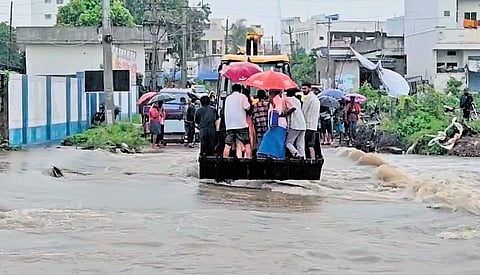

HYDERABAD: For the first time during this southwest monsoon, Telangana witnessed widespread heavy rainfall that triggered flood-like conditions across several districts, particularly in the northern parts of the state, under the influence of a deep depression.
During the 24 hours up to 8.30 am on Wednesday, Sarangapur in Jagtial district received a massive 20 cm of rainfall, followed by Buggaram, also in Jagtial, at 18.2 cm. Kaddampeddur in Nirmal district recorded 14.5 cm and Kamanpur in Peddapalli district 14.1 cm.
The intense rainfall significantly improved the state’s deficit, reducing it from 30% to 19%.
On Wednesday, Mulugu district recorded some of the heaviest rainfall, with several mandals receiving more than 10 cm of rain. Wazeed recorded the highest rainfall in the state at 15.4 cm, followed by Eturunagaram at 15.2 cm. Heavy rains also lashed Jayashankar Bhupalpally which saw over 11 cm rainfall, followed by Peddapalli that saw 10 cm rainfall, inundating low-lying areas, overflowing streams and causing waterlogging that disrupted normal life.
A tribal woman, Marsukola Paru Bhai (45), was washed away while crossing an overflowing stream at Ervachintal in Khanapur mandal of Nirmal district. Her body was later retrieved from the stream.
In Karimnagar, several cars were submerged in floodwater at Autonagar.
Heavy rains likely in north, northeast TG
Taliperu reservoir in Charla mandal of Bhadradri Kothagudem district, where water level reached rock bottom, came alive following heavy inflows triggered by rains in Telangana and Chhattisgarh.
Hyderabad remained under overcast skies throughout Wednesday, receiving intermittent light to moderate rain. While the city escaped the intense downpours seen in northern Telangana, continuous showers slowed traffic during office hours and led to waterlogging at several locations.

Anticipating heavier evening showers and peak-hour congestion, the Cyberabad traffic police issued an advisory to companies and organisations in the IT corridor, requesting staggered early logout timings to ease traffic congestion and ensure commuter safety.
Meteorologists attributed the widespread rainfall to the interaction of the deep depression over central Chhattisgarh with the active southwest monsoon. The system is drawing abundant moisture from the Bay of Bengal while its circulation extends across Telangana, creating convergence of moist winds and favourable atmospheric conditions for rainfall.
“The depression is moving slowly westwards and its broad circulation continues to influence Telangana. Since the system lies to the northeast of the state, districts on the northern and eastern side are receiving the heaviest rainfall. The system is also continuously pulling moisture from the Bay of Bengal, resulting in persistent cloud bands and widespread rain,” GN Srinivas Rao, a meteorologist at the India Meteorological Department (IMD), Hyderabad, told TNIE.
The IMD has warned that the rainfall activity is far from over. A heavy to very heavy rainfall alert has been issued for isolated places in north and northeast Telangana on Thursday, while similar conditions are expected over the northern and western districts on Friday.
The deep depression, centred over central Chhattisgarh on Wednesday morning, is expected to continue moving westwards over the next 24 hours while maintaining favourable conditions for widespread rainfall over the state.