HYDERABAD: A barely 20-minute spell of heavy rain exposed Hyderabad’s pre-monsoon preparedness as widespread waterlogging, massive traffic snarls, 76 tree falls and the collapse of part of an arch structure in the Old City were reported on Tuesday. Two youths died, purportedly due to electrocution, in Bandlaguda.
Dark clouds gathered over the city around 4 pm before heavy rain lashed several areas. Malkajgiri recorded the highest rainfall at 12.8 cm, followed by Musheerabad at 8.75 cm and Himayathnagar at 7.98 cm. In Chatta Bazaar, strong winds and heavy rain caused a railing and part of an arch structure to collapse, damaging two nearby shops. Former corporator Sohail Qadri of the AIMIM and rescue teams rushed to the spot. No injuries were reported.
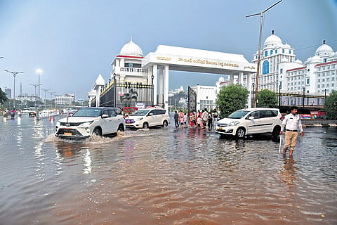
The downpour also severely disrupted traffic across the city, particularly in the IT corridor, where waterlogged roads brought vehicular movement to a crawl. In Madhapur, floodwater submerged roads and seeped into parked vehicles.
Tank Bund witnessed long traffic jams after strong winds uprooted trees. Waterlogging on the Tank Bund and roads in front of the Secretariat led to knee-deep flooding, prompting HYDRAA and disaster response teams to launch relief operations. Similar conditions prevailed in Hitec City, where roads were submerged under knee-deep water. Teams worked to clear flooded stretches and restore traffic flow.

Officials reported tree falls at 76 locations across the city. Uprooted trees at Kachiguda and Tank Bund further worsened congestion, forcing traffic diversions and one-way movement in some areas.
Expressing frustration, commuter Jay Soni, who was travelling from Hitec City to Bowenpally, said: “Due to waterlogging and civic failures, it took me 25 minutes to cover just 500 metres. What are all the pre-monsoon preparations for if the city comes to a halt after a short spell of rain? If this continues, citizens are going to face even worse conditions during the monsoon season.”
Another commuter caught in the gridlock near Madhapur posted on X that the city was “completely choked” within minutes of the downpour. “The rain wasn’t even that long, but the roads were flooded almost immediately. Traffic barely moved for over an hour,” the post said.
Residents in Hitec City also questioned the city’s preparedness. “Every year, the authorities claim they have completed pre-monsoon works, but the same areas get flooded after every heavy shower. It’s frustrating to see no improvement,” a resident said.
District in-charge minister Ponnam Prabhakar reviewed the situation in the evening and enquired about the impact of the downpour and the response measures being undertaken.
Heavy rain forecast for today
Meanwhile, the Hyderabad Meteorological Centre has warned of heavy rainfall at isolated places in parts of Telangana on Wednesday. Light to moderate rain is likely at isolated places across the state over the next three days, while maximum temperatures are expected to remain largely unchanged.
The IMD said the southwest monsoon has advanced into the remaining parts of the northeastern states, the whole of Sikkim and parts of Sub-Himalayan West Bengal as of June 9. Conditions remain favourable for its further advance over the next four to five days into more parts of the central Arabian Sea, Maharashtra, Karnataka, Telangana, Andhra Pradesh, the remaining parts of Tamil Nadu, and parts of West Bengal, Chhattisgarh and Odisha.
The weather department said a cyclonic circulation has formed over north interior Karnataka and adjoining areas at an altitude of 4.5 km to 5.8 km above mean sea level. The trough extending from east Uttar Pradesh to the north Andhra Pradesh coast through northeast Madhya Pradesh, Chhattisgarh and Odisha has weakened.