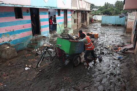
HYDERABAD: Hyderabad is sitting on a time bomb with the clock ticking. With nearly one-third of the city falling in high-risk flood zones and built-up areas expanding by 45% over the past two decades, experts warn that extreme rainfall events could pose an increasingly serious threat to the rapidly growing metropolis.
They pointed out that rapid urbanisation, shrinking water bodies and mounting pressure on drainage infrastructure impact the city’s ability to cope with intense rainfall. Large tracts of open land have been converted into residential, commercial and industrial zones, altering natural drainage patterns and increasing surface runoff, they added.
A study by researchers from the Tata Institute of Social Sciences (TISS) found that Hyderabad’s built-up area grew from 293 sq km in 2000 to 425 sq km in 2022, a 45% increase. As concrete surfaces replace open land, rainwater infiltration has reduced significantly, increasing the volume of runoff during storms.
It also found that around 70 sq km spread across 20 wards fall in the “very highly vulnerable” category, while another 144 sq km covering 55 wards are classified as “highly vulnerable”. Together, these areas account for more than 214 sq km exposed to significant flood risk.
Researchers observed that low-lying wards near river corridors and drainage channels consistently displayed higher flood vulnerability as water naturally accumulates in these areas during heavy rainfall.
The city’s flood history highlights the scale of the challenge. Hyderabad witnessed severe urban flooding in August 2000 after nearly 240 mm of rain fell in a single day. Similar flood events occurred in 2008, 2016, 2020 and 2021. In September 2016 alone, about 165 mm of rainfall was recorded within 24 hours, causing widespread inundation.
According to IMD data analysed in the study, annual average rainfall across Hyderabad ranges from 869 mm to 924 mm, with eastern parts of the city receiving more rainfall than central and western regions. While rainfall was assigned a lower weight than topography and urbanisation, researchers noted that intense downpours remain the immediate trigger for flooding when combined with poor drainage and extensive impervious surfaces.
Experts also point to the deteriorating condition of Hyderabad’s stormwater infrastructure. Silted drains, disconnected drainage networks, shrinking lakes, encroachments and solid waste dumping have significantly reduced the capacity of the city’s drainage system.
“Many parts of Hyderabad’s drainage network were designed for a much smaller city and are now struggling to cope with the runoff generated by rapid urbanisation and extreme rainfall events,” HYDRAA Commissioner AV Ranganath told TNIE. “Restoring lakes, nalas and natural drainage channels is critical because they serve as the city’s first line of defence during heavy rainfall.”
AI-based flood forecasts can help save city: Experts
Public policy experts Donthi Narasimha Reddy and Rajeev Mathew said ward-level vulnerability mapping should guide future planning. They advocated targeted interventions in high-risk areas, including drainage upgrades, restoration of lakes and wetlands, protection of natural drainage channels and stricter regulation of construction in flood-prone zones.
Mathew also emphasised the importance of technology-driven solutions. “Real-time rainfall monitoring, flood forecasting models, smart sensors and satellite-based observation systems can strengthen early warning systems. Integrating weather forecasts with AI-based prediction tools can help authorities issue timely alerts and improve emergency response,” he said.
INCOIS RINGS ALARM AS EL NINO TIGHTENS GRIP
Hyderabad: The El Nino event is strengthening and expected to peak during the coming winter, according to the latest bulletin shared by the Indian National Centre for Ocean Information Services (INCOIS). It added that sea surface temperatures across the Indian Ocean are likely to remain above normal until April–May 2027. INCOIS warned that the northern Indian Ocean, including the Arabian Sea and Bay of Bengal, could experience significant thermal stress, particularly between March and May 2027.
The agency said higher ocean temperatures could increase coral bleaching and marine heat waves, affecting marine ecosystems and fisheries. Commercially important species such as sardines and mackerel may be impacted as changing ocean conditions alter fish distribution and recruitment. The bulletin also noted that rough sea conditions in the Bay of Bengal could increase the risk of coastal erosion and flooding along the east coast, while the Arabian Sea is expected to remain comparatively calmer. INCOIS said the next bulletin will be issued in the second week of July.
