KOCHI: With Kochi being selected as the model city for the Local Biodiversity Strategy Action Plan under the Interact-Bio project being implemented by the International Council for Local Environmental Initiatives (ICLEI), a natural asset map will be prepared for the city. The map will list the natural assets of Kochi including marshy lands, mangrove patches, fallow land (paddy fields), ponds and canals.
Apart from Kochi, Panaji and Mangaluru are the two satellite cities selected for the project in India. The Interact-Bio is being supported by the German Federal Ministry for the Environment, Nature Conservation, Building and Nuclear Safety. The Strategic Action Plan will help the local bodies mainstream biodiversity and ecosystem services into core sub-national government functions such as spatial planning, land-use management, local economic development and infrastructure design.
“Though we have national-level and state-level biodiversity plans, none of the cities has a local-level strategy. In biodiversity conservation, local-level planning is a very critical element. Interact-Bio will support local bodies to understand and unlock the potential of nature to provide essential services and new or enhanced economic opportunities,” ICLEI (South Asia) Biodiversity Coordinator Monolisa Sen told Express.
Division of zones
The Local Biodiversity Strategy Action Plan is being implemented in Kochi on a pilot basis. A stakeholders’ meeting was held in connection with the plan implementation.Now the 74 wards under the Kochi Corporation will be divided into eight zones. “There will be eight zonal committees and two members from each ward/division will be members of their respective zonal committees. The biodiversity challenges from each division will be identified along with the specialities of each area. The Natural Assets Map will help in identifying the natural resources of each area,” said Rajan Chedambath, director of the Centre for Heritage, Environment and Development (C-hed), which is providing local body-level assistance for the project.
“A major meeting of the stakeholders will be convened for suggestions and recommendations, later this year,” he added.The toughest challenges that Kochi faces, as per their initial analysis, is the groundwater pollution and waste management. “Plans to tackle the challenges posed by climate change is another component of the plan,” added Rajan.
Subhash Park to be biodiversity interpretation centre
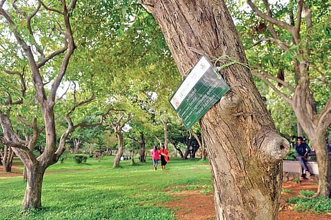
C-Hed is planning to convert the Subhash Bose Park, which is located in the city centre, into a Biodiversity Interpretation Centre. As a first step, the agency has listed all trees in the park which spreads across 11.5 acres. “A total of 434 trees belonging to 61 species are there in the park. We have already placed boards on each tree which contains the details including its Malayalam name, common name, scientific name and nativity. People are finding it very useful,” added Rajan. Among the trees in Subhash Bose Park, only 147 are indigenous while the remaining are exotic. “We are now working on the plan to convert the Subhash Bose Park into a biodiversity interpretation centre which will play a major role in developing the biodiversity plans of Kochi urban area,” he added.
