A unique exhibition of a wide range of maps of the Indian subcontinent, since the evolution of more accurate techniques of mapping from the 15th century, is on display at the National Museum in Delhi.
All the maps, except two, have been brought forth for the exhibition titled ‘Cosmology to Cartography’ by Hyderabad-based Kalakriti Archive.

The event, slated to end on October 11, unveils competing global interests and influences – religious, economic and political – that have contributed to the perception of ‘India’ as we understand it today.
National Museum Director-General Sanjiv Mittal said that the exhibition features an extraordinary variety of painted and printed Indian maps produced in the subcontinent and internationally, including original manuscript representations.
Prshant Lahoti, who heads the Kalakriti Archive, said the show would capture the development of the Indian printing industry, which although established by Europeans, came to be heavily influenced by Indian artistic styles and technology.
“Monumental original paintings of profound religious symbolism from the 15th to 19th centuries will be juxtaposed with ground-breaking historical maps of India, many of which are unique and have never before been placed on public view,” he pointed out.
Covering themes from pilgrimage to clashing empires, the exhibition begins with Jain and Hindu cosmological representations.
These then progress to magnificent painted hangings on a monumental scale depicting sacred rivers and pilgrimage sites and temple.
For example, Pichhvai of Vraj Yatra depicts the pilgrimage landscape of Vraj, the district around Mathura on the banks of the Yamuna river, and includes the sacred sites associated with Lord Krishna’s boyhood and the discovery of the Shrinathji image. It shows the route for the religious procession or Vraj Yatra which pilgrims undertake each year and lasts several weeks. Commencing from Mathura, the birth place of Krishna, devotees move in a clockwise direction around the city.
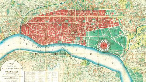
Another map provides an extremely detailed portrayal of Calcutta, which was then the capital of the ‘Company Raj’ and India’s pre-eminent commercial and cultural centre, with a population of almost 2,00,000 people. True to European Enlightenment era urban models, Calcutta is traversed by several broad thoroughfares, although by contrast most of the city is comprised of narrow, curving streets and alleyways, common to many traditional Indian cities.
The exhibition also features cartographic depictions of the ancient European conception of the subcontinent, and the first vaguely accurate maps of India made in the wake of Vasco Da Gama’s arrival in 1498.
Towards the more recent times are maps of medieval Hyderabad and Bangalore, and the enlightenment model of French Pondicherry. Visitors will also discover extraordinary plans of future metropolises such as Mumbai, Kolkata and Delhi.
Of the two maps sourced from the National Museum reserve, one is an 18th-century Rajasthani image of Lord Krishna, showing his cosmic Vishwaroopa form, while the other is a five-century-old watercolour work showing Hyderabad’s Nizam Ali Khan giving audience to French envoy M Bussy with the Walled City as a sprawling backdrop.