Coastal accretion double than shoreline erosion
BHUBANESWAR: Nearly 26 per cent of the 550 km coastline of the state is affected by sea erosion and 51 per cent of the shoreline is witnessing changes induced by accretion (deposition of sediment mostly sands). Replying to a question from BJP MP Aparajita Sarangi, Union Minister of State for Science and Technology and Earth Sciences Jitendra Singh on Wednesday informed the Lok Sabha that loss of habitation, vegetation and sand dunes; and damage to fishing hamlets have been reported from four coastal districts of the state due to changes in the shoreline.
The minister said that 140.73 km out of the total coastline of 549.5 km is affected by erosion while 280 km is witnessing the natural process of accretion. Accumulation of sediments is occurring on over 110 km of the coastline in Puri district. About 128.7 km of shoreline of the state is stable, he added.
In view of the natural changes of coastal erosion and accretion, loss of habitats have been reported from Kendrapara district and turtle nesting spot have been shifted from Bhitarakanika to Gahirmatha.
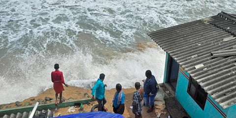
Loss of vegetation and sand dunes in Pentha and Satabhaya coast, loss of casuarina vegetation in Siali and adjoining areas of Jagatsinghpur district, degradation of fishing hamlets in Ramachandi, and tourist beach in Puri town and damage to fishing hamlets in Podampeta, Ramiyapatnam and Gopalpur of Ganjam district have also occurred.
The National Centre for Coastal Research (NCCR), an attached office of Ministry of Earth Sciences, has carried out a national shoreline change assessment mapping for Indian coast (including Odisha) using 28 years of satellite data from 1990 to 2018 to provide information for coastal management strategy.
In addition, Indian National Centre for Ocean Information Services (INCOIS), MoES has prepared the coastal vulnerability index (CVI) maps for the entire coastline of the country by using seven parameters.
Further studies have been done on multi-hazard vulnerability mapping to identify potential areas of coastal inundation for the mainland of India using data on extreme water levels, coastal erosion, sea-level change and high-resolution topography. On compensatory assistance provided by Centre, Singh said ministry of earth sciences only provides technical solutions to Odisha government in mitigation of coastal erosion.