BHUBANESWAR: The first post-monsoon cyclone over the Bay of Bengal (BoB) region will likely form by October 27 morning, said the India Meteorological Department (IMD) on Friday.
The national weather channel did not specify the path and landfall details but private forecaster Skymet claimed that the system will move close to the coastline of Tamil Nadu and Andhra Pradesh.
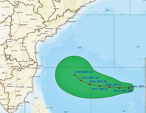
As per the IMD, a low pressure area which formed earlier in the day is likely to move west-northwestwards, intensify into a depression over south-east and adjoining central Bay of Bengal by Saturday and turn a deep depression a day later. It is expected to take shape of a cyclone over south-west and adjoining west-central Bay of Bengal by Monday morning (October 27).
However, the IMD said the tropical storm’s further path and intensity will be ascertained within the next 24 hours. Director of Bhubaneswar Meteorological Centre Manorama Mohanty said, “It is too early to predict the cyclone’s further intensity and path. A close watch is being kept over the system to find out if there is any possibility that it may re-curve too.”
Though IMD is yet to predict the cyclone’s further path, Skymet said, the low pressure area will intensify into a depression in the next 24 to 36 hours and keep moving west-northwestwards. “It is likely to get positioned over the south-central and adjoining south-west Bay of Bengal during this period. The system will constantly keep moving closer to the coastline of Tamil Nadu and Andhra Pradesh,” its bulletin suggested.
Under influence of the system, IMD said, Odisha is likely to experience heavy to very heavy rainfall from October 27 to 29. Coastal districts are expected to be most affected, Mohanty added.
The regional met office issued heavy to very heavy rainfall (64.5 mm to 204.4 mm) forecast for Ganjam, Gajapati and Rayagada districts on Monday.
While Nayagarh, Khurda, Puri, Jagatsinghpur, Kendrapara, Cuttack, Malkangiri, Koraput, Nabarangpur, Kalahandi, Kandhamal, Balangir, Nuapada and Boudh districts are expected to receive heavy showers (64.5 mm to 115.5 mm) during the period, some districts including those in the coastal region are likely to receive heavy to very heavy rainfall on Tuesday and Wednesday.
The regional met office said squally weather with wind speeds reaching 35 kmph to 45 kmph and gusting up to 55 kmph will likely prevail along and off Odisha coast from Sunday. The wind speeds will increase to 45 kmph to 55 kmph and gusting up to 65 kmph on Monday and 50 kmph to 60 kmph and gusting up to 70 kmph between Tuesday and Wednesday morning. It advised the fishermen to not venture into the sea along and off Odisha coast from Sunday onwards. Revenue and Disaster Management minister Suresh Pujari said the state government is closely monitoring the situation and prepared to face any eventuality.
