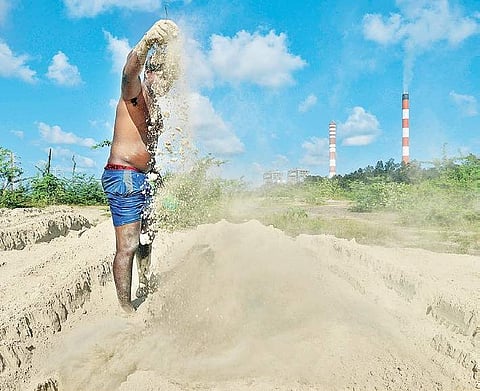

CHENNAI: A 1965 declassified aerial imagery acquired from United States space agency NASA shows how Ennore Creek and Kosasthalaiyar river basin has been exploited to the extant that it is now on the verge of extinction.
The three-member expert committee constituted by National Green Tribunal (NGT) has submitted the report after conducting in-depth scientific investigation into environmental impacts caused due to fly ash pollution. It has been revealed that illegal fly ash deposits have consumed an area of over 300 hectares across river, canal and water bodies and caused irreversible damage to topography and hydrology.
The three member expert committee of Sultan Ahmad Ismail, director of Ecoscience Research Foundation, D Narasimhan, retired associate professor of Department of Botany, Madras Christian College and Balaji Narasimhan, associate professor, Department of Civil Engineering, Environmental and Water Resources Engineering Division, IIT Madras had undertaken three independent investigations. They unanimously concluded that flyash pollution has injected poison (toxins) into every inch of environment in Ennore, be it air, water or soil, making it inhospitable for local communities, who had been dependent on the creek for ages.
The 65-page report, a copy of which is available with Express, says North Chennai Thermal Power Station (NCTPS), which is the main subject of the study, is guilty of constant fly ash spills and grossly under reporting the quantum of fly ash it generates and utilises.
“As per a note dated July 31 submitted by TANGEDCO to the tribunal, the total estimated quantum of settled fly ash is 2,18,257 cubic metres. However, this is only less than two per cent of the total fly ash volume actually spilled. More than 98% of fly ash has to be accounted for and recovered from the site,” the report said.
Discrepancies found
Narasimhan said as per TANGEDCO claims, the volume of fly ash remaining in the Dykes of NCTPS after utilisation should be between 6.11 million cubic metres (Mm3) to 8.11 Mm3. However, the fly ash estimated to be in the pond is 18.12 Mm3. “10.01 Mm3 to 12.01 Mm3 more (in excess) fly ash is present in the Dykes than what is reported by NCTPS. This means either no spill has happened (which is contrary to the observation on the site) or utilisation as reported by NCTPS has not actually taken place or more fly ash than reported by NCTPS has taken place during the power generation,” he said in the report and recommended a thorough audit of all records regarding fly ash generation and fly ash utilisation to check for errors in reporting.
The total installed capacity of two fly ash Dykes of NCTPS is 18.85 Mm3 and the current storage is 18.12 Mm3. The Union environment ministry notification mandates that there should be 100 per cent utilisation of fly ash before December 31, 2017. The notification makes it mandatory for cement industries, within a radius of 300 km of a coal or lignite-based thermal power plant, to use fly ash for manufacture of the cement as per the specifications of Bureau of Indian Standards (BIS).
The cost of transportation of fly ash is to be borne collectively by the thermal power plant and the industry concerned. Further, every construction agency engaged in construction of roads would be bound to use fly ash in accordance with the guidelines or specifications issued by the Indian Road Congress.
In response, SN Raveendran, superintending engineer, TANGEDCO, who was present in the tribunal, blamed cement industries for not taking the fly ash. Justice MS Nambiar, who is heading the single member NGT bench, came down heavily on TANGEDCO for being least bothered about the ecology and the risks posed to the local inhabitants.
Overall damage huge
The expert committee members said the study was conducted in a limited area as the scope of NGT order was restricted to fly ash contamination caused by NCTPS. The committee said fly ash ponds of three power plants — NCTPS, the now-closed Ennore Thermal Power Station and Vallur Power Plant — are located in and near the creek. Only a comprehensive study of the entire Kosasthaliyar river basin would reveal the actual damage caused, which is likely to be immense. There is also the Kamarajar Port, which is constantly in the news for illegal dumping of dredged soil and reclamation of wetland.
Telltale photos
Recent Google Earth imagery and field survey establishes that the extent of fly ash spill noticeable is 344.39 hectares
This 1965 high-resolution image acquired from NASA shows the affected area with salt spans
Drone study sought
The committee intended to map the affected area using drones to get a more accurate picture of the extent and intensity of the contaminated area. However, it could not be carried out due to want of clearance from Director-General of Civil Aviation. A drone survey will be essential for improving the estimates