CHENNAI: The northeast monsoon rocked the city on Wednesday. To help commuters, Riskmap in association with Citizen Consumer and Civic Action Group and MIT Urban Risk Centre is deploying a real-time flood map where residents can update changing water stagnation levels in their respective areas.
Users can either log into Riskmap.in and submit pictures of flooding and provide details or submit information through social media apps such as Twitter, Facebook, Instagram and Telegram.
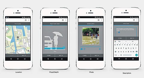
The designated chatbots will send a one-time link to submit location, flood depth, pictures and description.
“Through the live map, residents and government officials will also be able to inform each other about dynamically evolving situations in the city and help each other navigate to safety,” said a release from the organisation. In addition to flooding, residents can also share infrastructure disruption information such as fallen trees, electrical outages, exposed cables, and blocked drains.
The pilot project for the flood map was run between November 1 and November 6 last year, and officials from Riskmap claim that over 250 flood complaints were received on November 3, 2017 alone and that around Thirteen thousand users were accessing the map during heavy rainfall spells.
