CHENNAI: The public hearing for the mega expansion of Kattupalli Port proposed by Marine Infrastructure Developer Pvt Ltd (MIDPL), a vertical of Adani Ports, is scheduled on January 22.
Tamil Nadu Pollution Control Board (TNPCB) officials told The New Indian Express that the Environment Impact Assessment (EIA) study for the proposed revised master plan development of Kattupalli port has been completed and submitted to the board.
"The public hearing will be conducted at 11 am on January 22 at Bhagavaan Mahaveer Auditorium in Chandraprabhu Jain College in Minjur," a top official from TNPCB said.
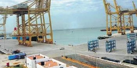
The Kattupalli Port expansion has been proposed in a total area of 2,472.85 hectares which includes 133.50 ha of existing area, 761.8 ha of government land, 781.4 ha of private land and proposed sea reclamation of 796.15 ha. When completed, Kattupalli Port will be one of the largest major ports in the country enhancing the cargo handling capacity from the current 24.66 MTPA (million tonnes per annum) to 320 MTPA. Adani will be pumping in an investment in excess of Rs 53,000 crore.
However, the project would eat into wetlands of the fragile Ennore ecosystem and is likely to pose a significant threat to India's second largest brackish water lake - Pulicat lake. An expert appraisal committee of the Union Environment Ministry, before issuing Terms of Reference (ToR) for MIDPL to conduct EIA studies, had constituted a sub-committee to inspect the project site after receiving several complaints from local people and activists.
In its report, the sub-committee noted that Pulicat lake in the north of Kattupalli port, Ennore creek in the south with the Buckingham canal on the west are designated as ecologically sensitive areas and
placed under CRZ-1 (critical for maintaining ecosystem of coast) of Coastal Regulation Zone (CRZ) Notification, 2011.
"Extensive shallows (Ennore shoals) are formed at this place and they extend up to Pulicat. The coastal area near Pulicat is very flat and has a vast expanse of backwater including saltpans. It has been hypothesized that shoals might have formed due to interaction of northerly coastal currents and sediment supply through Ennore creek (Kosattalaiyar river) when it was active," the committee said and recommended a detailed study on the impact of the port expansion on the Ennore shoals that were protecting the coast from cyclones and tsunamis.
The sub-committee had also recorded and endorsed the concerns of local people, with regard to protection of the Kosasthalaiyar estuarine wetland ecology with its brackish water channels, salt pans, mud flats, mangroves, sand dunes, palmyra stands and endemic flora and fauna, running parallel to the coast and linking Ennore creek, Karungali estuary and Pulicat lake. It is critical to the effective drainage of the massive volumes of flood waters received from inland and the dissipation of the storm surge energy from the ocean. This naturally evolved earth system is crucial in maintaining fresh water recharge and countering saltwater intrusion.
However, in the executive summary of the EIA study, MIDPL claims that the proposed port location does not contain environmentally sensitive areas and it also does not include breeding and spawning grounds of fish and other marine life, areas of outstanding natural beauty, historical or heritage areas and areas rich in genetic diversity. "The development activities such as capital dredging, reclamation, dredge spoil disposal, expansion/modification of navigational facilities, offshore structures will impact the marine environment. However, most impacts during construction are short-term in nature and will cease on completion of construction activities," the study report claims.
MIDPL also claimed that to prevent the erosion along the north coast, both soft (sand bypassing) and hard measures (groynes) were tested with appropriate model simulations. "The model analysis also clearly shows that the Pulicat lake mouth will not have any impact due to the proposed development and protection measures considered," it said.
