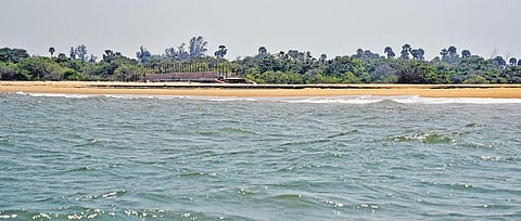

SRIHARIKOTA: Sriharikota island, India’s spaceport and a critical facility, is eroding. This is partly because of the growing port infrastructure in Chennai, say coastal scientists conducting shoreline studies to understand the problem.
When contacted by Express, M Srinivasulu Reddy, controller at the Satish Dhawan Space Centre (SDSC-Shar), said, “Yes, we are experiencing a little erosion, especially on the northern strip of the island. We requested scientists from the Chennai-based National Centre for Coastal Research (NCCR) to undertake studies and recommend solutions. We are yet to receive a report from them.”
As for how much area of the island, which is home to ISRO’s rocket launch station, has been lost, Reddy said, “We don’t know. NCCR scientists are studying it.” But as per rough estimates, based on Google Earth images and visual evidence from the ground, at least 200-300 m of the beach has been eroded in the past decade.
Express has visited at least half a dozen villages abutting Sriharikota island on the north. Only the Pulicat Lake bar mouth separates these traditional fishing villages from the highly-guarded Sriharikota island. Fishermen in Navapetta, Monapalem, Kondurpalem, Srinivasapuram, Vadapalem, Manjakuppam and Govindapalipalem villages say that though there isn’t a drastic change in the coastline, “beaches are eroding slowly and steadily”.
Growing port infra in Chennai erodes spaceport in Sriharikota
A Arumugam (51), a fisherman from Rayadaruvu village, says the erosion at Sriharikota has been getting worse every year. “The old pier bridges have been taken over by the sea, so the Shar authorities built new ones, and even they are under threat now.” Arumugam, who holds a marine fisheries identity card issued by the Union Ministry of Agriculture, said Sriharikota is the country’s pride and needs to be protected at any cost. “Our coasts are protected because of Sriharikota barrier island. Many children from fishing villagers here study at schools in Sriharikota.
It’s our lifeline in many ways.” On taking a boat ride along the island, Express witnessed the partially-submerged bridges. Compared to other areas along the coastline, the wave energy near Sriharikota Island was intense. When contacted, a top NCCR official told Express that Shar authorities contacted NCCR some three months ago regarding the problem of sea erosion. A report on changes in the Sriharikota shoreline will be ready by June and submitted to Shar authorities.
“For the last two months, our team has been conducting shoreline studies along Sriharikota Island and further up north. Our initial assessment shows the coastal areas are subject to erosion due to both natural and anthropogenic activities. However in recent days, low-pressure systems and sea-level changes have increased and hence more erosion is noticed at Sriharikota. The net littoral drift is towards the north and hence eroded areas are usually noticed north of any development.
The only way to manage the coast is to balance the sediment budget with proper analysis of natural and man-made activities.” The noticeable structures that scientists are referring to and that can block the longshore sediment transport impacting Sriharikota island are breakwaters built by multiple ports in Chennai. Remember, Sriharikota island is located north of Chennai ports. It is a well-established fact that ports with protruding breakwaters built on a coast cause alteration to the flow of sediments along the shore and trigger erosion north of the structures, while helping beaches grow on the south.
This is the reason north Chennai beaches are eroding and Marina Beach, which is south of Chennai port, benefits from a constant sand supply. Rajesh, member of Marine Coastal Security Police at Dugarajapatnam in Nellore district, also confirmed that a team of coastal scientists carried out studies up to 12 nautical miles into the sea last month.
In Puducherry, scientists from the National Institute of Ocean Technology (NIOT) deployed wedge-shaped nearshore artificial reefs to fight sea erosion in 2017. It was a first-of-its-kind eco-friendly design developed and successfully implemented in India, breaking way from conventional solutions like seawalls and groyne fields, which are becoming increasingly unpopular worldwide as they are known to shift the erosion further north. However, these submerged soft structures like the one deployed in Puducherry allow the sand to bypass, thereby helping beach formation on the either side.
After nearly two decades, today there is about 300 m of beach in Puducherry, restoring some of its lost glory. Besides, Nellore district collector KVN Chakradhar Babu says the Sriharikota Island and the adjacent Pulicat estuary has been declared an ecologically-sensitive area and erosion is a matter of serious concern. This means building hard structures like a seawall or groynes are not recommended. “Shar authorities have not flagged the issue of erosion with the district administration as yet. We are ready to provide any assistance, if needed, in terms implementing anti-erosion measures,” Chakradhar said.
When does a littoral current occurs?
A littoral current occurs when waves break at an angle to the shoreline. The waves’ current and their turbulence lead to movement of the sand along the shoreline. As waves approach the beach at an angle, the up-rush of water, or swash, moves the sand at an angle, according to oceanography experts