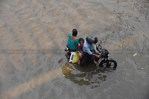
CHENNAI: To tackle the issue of recurrent inundation during heavy rains, the Third Master Plan of the Chennai Metropolitan Development Authority (CMDA) is going to map and incorporate the city’s water catchments and rainwater flow patterns by superimposing them on the future land-use plan, and ensure the natural flow of water is suitably channelised, according to CMDA member secretary Anshul Mishra.
He pointed out that, at times, water channels flow on both public and private land. “Officials have only been verifying ownership of the land for granting planning permission rather than looking at whether the natural flow of rainwater will be impacted. Any construction blocking the natural flow of water without provision for adequate drainage might result in floods,” says Mishra.
The Third Master Plan would adopt a flood-sensitive planning permission regime. All planning permissions will also require a No Objection Certificate (NOC) from the Public Works Department (PWD) from an inundation point of view. But the biggest challenge for the city during floods has been multiple agencies working in silos when it comes to water management and preparation of plans to reduce floods.
ALSO WATCH | Chennai Rains: How community kitchens are feeding flood-hit urban-poor
Prof S Janakrajan, president of the South Asia Consortium for Interdisciplinary Water Resources Studies, told TNIE there should be a nodal agency to take care of floods and it should have statutory powers and representation from all departments. “At the moment, the activities are not coordinated. The river is under the control of the PWD, drinking water is under the control of Chennai Metro Water, land is under the Revenue Department,” he says, adding that the State government must appoint a permanent committee for water management.
Aswathy Dilip, South Asia Director at the Institute for Transportation and Development Policy, said floods in Chennai come as a shock and are then forgotten. Janakrajan also highlighted the need to protect flood plain zones. “We have flood plain zones in the Cauvery. The width of the river is about 1 km. This is lacking in the Cooum and Adyar rivers,” says Janakrajan.
Interestingly, the State has yet to enact Flood Plain Zoning (FPZ), a concept to regulate land use in the floodplains to restrict the damage caused by floods and determining the locations and extent of areas for developmental activities so it doesn’t affect the environment. It was mandated by the Central Water Commission, which in 1975 circulated a model Bill of FPZ. Even the Second Master Plan of Chennai prepared by CMDA’s planners did not provide for FPZ.
“Do we have the demarcations of a river? Do we have data to show this is the floodplain of Cooum River or Adyar River? In Tamil Nadu, they hardly know what a floodplain is. They don’t remove encroachments on floodplains,” he said.
He also hits out at the plans to create walls along the Adyar and Cooum rivers. “Rivers need a drainage of water from both sides,” he said, adding that rivers can’t be restored without a benchmark, and should be restored on the memoirs from 100 years ago.
‘WALLS ALONG aDYAR, cOOUM BAD IDEA’
Prof S Janakrajan hits out at plans to create walls along the Adyar and Cooum rivers. “They are transforming these rivers into canals. It is a very bad idea. Rivers need to have a drainage of water from both sides. I have been raising this issue with the Chennai River Restoration Trust,” he says
ALSO WATCH | Just two days of rain turn Chennai roads into obstacle course for commuters:
