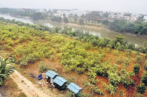
CHENNAI: The Chennai Metropolitan Development Authority (CMDA) has approved a proposal to reclassify six acres of land in Nandambakkam, which was marked as a portion of the Adyar river in the second master plan map as a residential and institutional zone.
The six acres of land were denied permission to be reclassified for the past 17 years. The previous authority meeting which had planned to reclassify the particular portion of land termed could not proceed after protests by NGOs, which questioned the revenue record put forth by the private entity.
The water resources department said the boundaries were demarcated by the revenue department during the construction of a compound wall on the western side abutting the Adyar River. “The site needs filling up to the depth of 1.2m to 2.69m from the existing level in order to protect inundation,” said the agenda tabled during the authority meeting. Similarly, Greater Chennai Corporation has said it has to re-examine the regularisation approval for the plot.
Another proposal was to reclassify a portion of Periya Eri as residential use zone. It was classified under the second master plan as a waterbody. According to a report from tahsildar, which was tabled during the authority meeting, the records changing it from waterbody to punjai is not available.
Meanwhile, a study comprising 43 teams and consisting 86 CMDA officials was conducted on the land use plans, which marked waterbodies in the first and second master plans in Chennai Metropolitan Area. The survey found 1,011 waterbodies were marked during the first master plan. In addition, some were given the land use of open space and recreational use (124), partly open space and recreational use and partly waterbody (155), which tallied to 1,290.
The second master plan has 2,131 waterbodies. For 687 cases, there was a lack of information and among these, 60 are government lands classified as waterbodies in Adangal, 81 as government lands, 126 as private patta lands and 420 as lands for which ownership and FMBs awaited.
It is learnt that the collectors and district revenue officers of Chennai, Thiruvallur, and Kancheepuram were asked to furnish details of A-register, Adangal, patta for the 420 cases to ascertain the status. Sources said the final report on the 687 waterbodies will be submitted to the government soon.
Former chief planner Dr K R Thooyavan, who helped in the preparation of the first master plan, told The New Indian Express that waterbodies in the first master plan were marked as open space and recreational use by the first chief planner of CMDA G Dattatri so that they could not be converted into the built-up area. “We did not classify them as waterbodies,” said Thooyavan, who claims most of the records have been lost.
Background at a glance
The six acres were denied permission to be reclassified for the past 17 years. The previous authority meeting, which had planned to reclassify the portion of land termed could not proceed after protests by NGOs, which questioned the revenue record put forth by the private entity. The water resources department said the boundaries were demarcated by the revenue department during the construction of a compound wall on the western side abutting Adyar.
