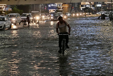
HYDERABAD: The city was ambushed with heavy rains and thunderstorms in the evening hours, leading to deluge, traffic jams, forcing people to switch from sun coats to raincoats on Friday.
What started as a light wind rain turned into severe downpour and thunderstorm, making it difficult for people to drive, forcing commuters to take refuge under flyovers and metro bridges.
Street vendors were also forced to close their businesses as the rains intensified.
Two-wheelers and auto rickshaws struggled to wade through heavily waterlogged roads even as the rains affected the visibility.
The downpour continued for more than two hours, flooding several roads and colonies across the cities.
Areas such as Tolichowki, Shaikpet, Raidurgam, Jubilee Hills, Banjara Hills, Film Nagar, Nanal Nagar, Langer Houz, Golconda, old city areas, Masab Tank, Khairatabad, Tank Bund, RAj Bhavan Road, Lakdi Ka Pul, Punjagutta, Somajiguda, Begumpet, Prakash Nagar, Secretariat road, SD Road, Mettuguda, Uppal, Secunderabad, Rani Gunj, Nampally, Koti, Abids, Moazzam Jahi Market, Afzal Gunj and other areas experienced severe water-logging, obstructing the commute on the way.
Traffic personnel could be seen directing people on the roads and also unclogging the drains for clearing the flooded roads.
Light rains were also experienced in the districts of Medchal-Malkajgiri, Vikarabad, Siddipet and Medak.
The highest rainfall in the state was recorded at Santoshnagar at 63.2mm in Hyderabad, as per the TGDPS report.
IMD said a trough runs from North Madhya Maharashtra to the Gulf of Mannar across Marathwada, interior Karnataka, Rayalaseema, Tamil Nadu, at 0.9 km above mean sea level and mainly low-level Southerlies/South-Westerlies prevail over the state.
The state will continue to experience light to moderate rains or thundershowers for the next six days.
IMD has issued a yellow alert for thunderstorm accompanied by lightning and gusty winds of 30-40 KMPH at isolated places in the districts Mulugu, Bhadradri Kothagudem, Khammam, Nalgonda, Suryapet, Mahabubabad, Warangal, Hanamkonda, Jangaon, Siddipet, Yadadri Bhuvangiri, Rangareddy, Hyderabad, Medchal Malkajigiri, Vikarabad, Sangareddy, Medak, Kamareddy, Mahabubnagar, Nagarkurnool, Wanaparthy, Narayanpet, Jogulamba Gadwal.
For the next 48 hours, the city will experience a generally cloudy sky. Light to Moderate rain or thundershowers accompanied by gusty winds of 30-40 kmph is very likely to occur in the city. Maximum and minimum temperatures are likely to be around 37 degrees Celsius and 26 degrees Celsius, respectively. Surface winds are likely to be southwesterlies with wind speeds around 06-08 kmph.
