KOCHI: The biodiversity heritage tag for the Kanichamthura Oxbow Lake, a unique lake formed in the shape of ‘U’ shape at Vynthala, near Mala, has proved elusive after the National Biodiversity Authority refused to give the rare tag to the freshwater body in the wake of suspicion over its shape.
Speaking to ‘Express’ Dr K P Laladhas, Member Secretary, Kerala State Biodiversity Board, said the proposal for conferring the unique biodiversity heritage tag on the lake seemed to have hit a hurdle at the eleventh hour with the Central authority raising suspicion over the shape of the lake.
However, the state government has decided to protect the lake after demarcating the area and raising riparian vegetation along the area to conserve the unique biodiversity spot.
A proposal in this regard was ratified by the government and the area was demarcated by the district administration for this purpose, he said.
According to experts, it is considered that the riparian vegetation will slow down flow of water, which would maintain and protect the lake banks. The riparian vegetation like native grasses, shrubs, flowering plants and trees to be planted in the area will also allow water to soak into the ground and recharge groundwater around the area, they say.
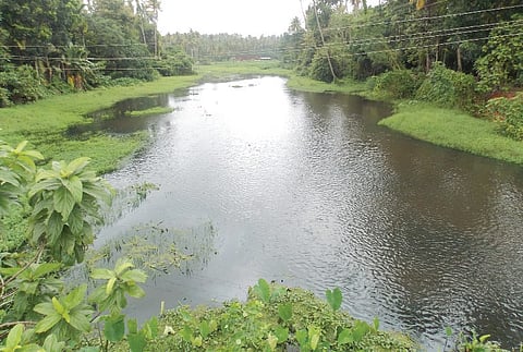
The oxbow lake situated at Kadukutty panchayat was languishing in neglect for the past few decades after it witnessed siltation and weed infestation, that have posed a serious threat to this rare fresh water lake’s survival.

The lake was naturally formed adjacent to the Chalakudy River in the shape of oxbow, a ‘U’ shaped curve in the stream, but it has turned a picture of neglect in recent years with the inflow of water from Chalakudy river to the lake getting reduced over the years.
According to a study conducted by Dr Sunny George, limnologist and head of the Water Institute at SCMS College, in 1998, it is believed the flow of the water from the river got slowed down at Vynthala and a ‘U’ shaped channel was carved out separately, the process is called meandering; as a result, a huge quantity of soil coming from the mountain was deposited on that side of the river.
Later, when the floodwaters receded, the river then continued in its old channel but the trapped water remained there as a landlocked lake, leading to the formation of oxbow lake.
How are oxbow lakes formed?
Oxbow lakes, which have immense importance from ecological point of view, are generally found near large rivers and their formation is a natural process happening during several centuries of time. Formation of oxbow lake is a very time-consuming and interesting process. A river meanders or takes a winding course while it is faced with obstruction for its natural flow. As the river meanders with the irregularities of the topography of the area, greater erosion occurs on the outer concave side of the river bend while deposition of soil dominates in the convex side. With the passage of time, erosion and formation of the concavity continues until the U-shaped meanders of the river loses in upon itself. Later, in a flood or in some natural changes, the main course of the river cuts a channel through the initial position of the mender isolating the loop. Eventually, through the deposition of the alluvial soil, the loop gets detached from the main channel forming the lake and the name oxbow is given to such lake to denote the U-shaped frame forming a collar along an the neck of an ox.
The oxbow near Chalakudy river
The oxbow lake identified at Vynthala is 2.5 km long and only less than around 300 m alone remains relatively undamaged.
The National Biodiversity Authority officials who visited the lake sometime ago claimed that the lake should be in the form of beans shape, while the lake formed in Vynthala was not in that line.