Across the world, many dams are being dismantled to allow rivers to regain their natural course. But they are, no doubt, architectural marvels and feats of human engineering that hold at bay the enormity and the sheer force of nature. But even to the casual observer, it is indeed a spectacle, especially during the rain. It evokes beauty, poetry and even peace.,
It is all a tranquil scene till the rain picks up force and the skies start pouring sheets of water. The roar of the waterfall when the shutters are raised to let out the stress caused by the water volume creates, no doubt, an inexplicable fear of elements even in those minds that have seen the dam in its peaceful times.
Last week, as rains lashed Thiruvananthapuram, the scene was quite similar when all three major dams in the district swelled to a near-fiery level. In calmer times, the waters flowing from Peppara, Aruvikkara and Neyyar seem placid, in submission to the human will, and ready to cascade downstream to irrigate, to nurture and to enliven.
But the incessant downpour infused the water with the ferociousness of gritty animals in the wild, struggling to break free from their enclosures. When nature, finally, showed its muscle, humans waited and watched for the fury to sober down.

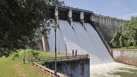
Neyyar dam has been a chosen getaway for Trivians. Tourism has been a great aside at the dam, though it was set up in 1958 primarily for irrigation purposes. The river, which translates to ghee river, originates from Agasthyamala. The reservoir, spread over 91 sq km and 56 metres long, is a rubble masonry gravity type.
The catchment area of 140 sq km is within the Neyyar sanctuary and the Agasthyamala Biosphere Reserve. The boat ride on the upper catchment of the dam is famous, and this was feared to be stopped in the rains that hit the district recently.
“We kept a very close watch. Probably that’s what the 2018 floods taught us. Every four hours, we update the level on the Centrally-monitored WRIS app,” says Siddique M S, assistant engineer who’s in charge of the reservoir.
The people who live around the dam, however, were very wary. “Our houses get submerged,” says Sulochana, who sells spiced fruits at the dam area. The settlements in the catchment area where around 400 families live are under threat of such flooding during rains, says Siddique.
Four shutters of the dam have been raised by 20 cm to let out the water swell to 83.60 metres. The full capacity is 84.75 metres. Despite this, the dam was kept open to visitors, some of whom were seen catching the glory of the creamy waters spilling out from the shutters from up close.
“The management of dams nowadays shows a marked change. Till now, it was more for storage. In the times of rain, the operation should include flood control. The IMD could speed up its alert to facilitate better planning,” says Manoj M, executive engineer of Kerala Water Authority (KWA).
Further upstream, Peppara remains closed to visitors. One family who came from Chennai and a group of women were turned back, and they drove away to seek other pleasures of the forest — in drives around the sanctuary, and lunch from the restaurant that served forest produce.
Inside, towards the dam area, the watchers and Prakash S P, the operator, walk up to read the water level at 104.75 metres. “The full capacity is 110.50. We raise the shutters when it crosses 107.50 metres. This time, it did rain heavily, but we did not have to raise the shutters,” he says. But the situation was different during the Ockhi. “It was real danger. The level went beyond 107.5 metres, and we had to raise all four shutters by 50 cm,” says Shahjahan, a watcher at Peppara.
The entire catchment area of the dam is around 83 sq km. The 423-metre-long dam unifies all the upper tributaries of the river Karamana, such as Attayar, Kaviyaar, Thodayar, etc. The water here is clean, the scene around the dam is picturesque, with the Western Ghats walling the catchment area and sanctuary nestled in the woods. The staff of KWA, who manage the dam, stay there overnight to check on the level. The Podiyakkala and Podiyam tribal settlements are the ones that get affected due to the rains, but there are stone markers to alert of the rise of water in the dam. “In Podiyakkala, the road may get blocked in the rain,” says Prakash.
Peppara is vast, and its hugeness contains the possibilities of risks. It is relatively young as well, being built just in 1983. The grandness of the water volume creates a magic that pulls people towards its immeasurable charm.
“This is not a tourist area, and is in fact a restricted one. When we closed two days ago, many insisted on being let in. What they do not understand is that it may not be raining in the dam area, but rain anywhere in the Ghats will cause a ripple effect here, as the water sources from there feed this river. When the waters swell, we cannot say,” Shahjahan says.
In the case of Aruvikkara, the fierceness was always embedded in its atmosphere. The rocks that lay on the course of the Karamana River, over which the dam was built in 1933, were always tricky. During non-monsoon times, they welcome nature lovers, standing out from the waters that stormed down foamy but calmed out to be crystal clear as they neared the quaint Devi temple at the banks, a heritage structure built in the 8th century.
There are several stories associated with the temple that the locals recall. “Have you seen the marks on the rock by the riverbed? That is said to be the footprints of the Goddess and is worshipped. People are advised not to walk over that,” says Sukumaran Nair, who runs a tea shop by the side of the dam.
The entire setting turns frightfully alluring when rain pours down. Getting into the water then could mean being swept away. “Visitors do not listen to us and suffer by either being swept away or being injured,” he says.
This time too, the scene was no less fiery when the district received incessant rains till May 31. Five shutters of the dam were raised 10 cms each to let out water that had swelled beyond the 46.6 metre level capacity of the dam — a small, gravity-type dam built over 90 years ago.
In the rain this time, the water level remained contained because the Peppara, which supports Aruvikkara, did not have to be raised. The shutters let out the surge in level. “There was no flooding downstream because of this,” says Manoj M, executive engineer, Kerala Water Authority (KWA).
Yet, Aruvikkara maintained a careful restraint, closing the gates towards the dam so that visitors do not meander towards that area.
“You should have seen on Saturday. Water was roaring over the rocks, sending shivers down our spine,” says Ashwin Sreeja, showing the pictures of the scene that he posted on social media. “Aruvikkara is always a sensation — in rain or shine,” he smiles.