VIJAYAWADA: The Andhra Pradesh Capital Region Development Authority (APCRDA), which has proposed an Inner Ring Road (IRR) in Amaravati to provide a quick and congestion-free access to the new capital, has finalised the alignment of the road project. The 96.25-km IRR will provide a link between Amaravati, Vijayawada and Guntur.
The officials said that the alignment has been finalised after going through 1,185 suggestions and objections raised by the landholders whose property would be affected due to the project. A committee, headed by additional commissioner S Shan Mohan, was formed to look into the objections and suggestions. After examining them during nine public hearing meetings, the committee recommended only minor changes to the draft alignment proposed, as most of the suggestions and objections were related to land procurement methods, not the structure.
“Most of the objections and suggestions were related to either land procurement methods [such as land pooling scheme and land acquisition], or the willingness of the farmers/applicants to give their lands for the notified roads. They were not related to road alignment. Hence, the committee recommended that the draft notification issued holds good. In some cases, minor modifications were recommended,” the report of the committee stated.
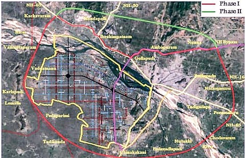
The recommendations were also approved by APCRDA last month. Subsequently, a gazette was issued notifying the final alignment of the IRR, which will also be connected to the 27 arterial roads of the capital city. “The gazette was issued on October 31. The proposed IRR passes through 41 villages of Krishna and Guntur, including a minor part of Kondapalli Reserve Forest, and it requires 3,521.76 acres to be constructed,” an official explained. The authority had to make amendments to the Zonal Development Plans of a few villages and tweak the master plan of Amaravati to accommodate the IRR, as a few areas were not a part of the master plan.
The eight-lane IRR, which will have a right-of-way of 75 metres, will be taken up in two phases. The first phase, of the length of 68.08 km, will be between NH-65 (at Kethanakonda on Hyderabad Highway) and NH-16 by-pass (at Vedurupavuluru) via Chinakakani. The second phase, of 28.08 km, will be between NH-16 by-pass (at Vedurupavuluru) and NH65 (at Kethanakonda on Hyderabad Highway) via Kondapalli. Now that the alignment has been finalised, the authority will work on the modalities of land procurement, the officials said.
