EXPLAINER | Taking a closer look into the cause and effects of climate change in India

From extreme heatwave to unseasonal rain, resulting in heavy flooding, to ground water depletion, effects of climate change are real and likely to increasingly impact more and more people.
A man attempts to open an umbrella during a stormy weather as sea water enters Chellanam area following heavy rainfall in Kochi. (File Photo | PTI)

From extreme heatwaves to unseasonal rain, resulting in heavy flooding, to groundwater depletion, the effects of climate change are real and likely to increasingly impact more and more people. This newspaper website takes a closer look at the cause and effects of climate change in India.

Climate Change Impact

Rainfall Patterns

An abrupt change in the monsoon could trigger more frequent droughts as well as greater flooding in large parts; the Northwest coast to the southeastern coastal region could see higher than average rainfall

Drought

In 1987 and 2002-2003, droughts affected more than half of India’s crop area and led to a huge fall in crop production; Droughts are expected to be more frequent in north-western India, Jharkhand, Orissa and Chhattisgarh

Groundwater

More than 60% of India’s agriculture is rain-fed; Falling water tables may reduce due to increasing demand for water from a growing population

Glacier Melt

Melting glaciers and loss of snow cover over the Himalayas may threaten reliability of northern India’s primarily glacier-fed rivers, particularly the Indus and the Brahmaputra
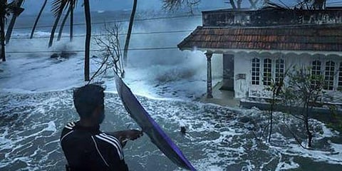
Sea level rise

Mumbai has world’s largest population exposed to coastal flooding; Sea-level rise and storm surges would lead to saltwater intrusion in the coastal areas, impacting agriculture, degrading groundwater quality, contaminating drinking water; Kolkata and Mumbai are particularly vulnerable to the impacts of sea-level rise

Food security

Seasonal water scarcity, rising temperatures, and intrusion of sea water would threaten crop yields, jeopardising food security

Energy Security

Increasing variability and long-term decreases in river flows can pose a major challenge to hydropower plants and increase the risk of physical damage from landslides, flash floods, glacial lake outbursts

Water Security

An increase in variability of monsoon rainfall is expected to increase water shortages in some areas. Threat to water security is very high over central India, along the mountain ranges of the Western Ghats, and in northeastern states

Health

Heat waves are likely to result in a very substantial rise in mortality and death, and injuries from extreme weather events are likely to increase.

Migration

Climate change impacts on agriculture and livelihoods can increase the number of climate refugees.

- Source: World Bank

Kerala

  • 60% Of 590 km long coastline prone to sea erosion
  • 1,848 sqkm Area on the Kerala side of the Western Ghats is prone to landslides
  • Climate change hotspot districts: Alappuzha,Palakkad, hilly districts of Wayanad and Idukki
  • Flood prone: Alappuzha, Thrissur, Kottayam, Ernakulam
  • Landslide: Wayanad, Kozhikode, Palakkad, Thrissur, Idukki, Kottayam, Pathanamthitta, Malappuram, Kollam
  • Coastal erosion: Thiruvananthapuram, Alappuzha, Ernakulam, Malappuram

Maharastra

  • Average rainfall of 1,124.29 mm against 1,007.3 mm annual average rainfall
  • Sensitive districts: Pune, Satara, Solapur, Nasik, Jalgaon, Wasin, Ahmednagar, Beed, Latur, Washim, Yawatmal, Dhule, Jalna, Akola, Bhandara, Buldhana, Nagpur, Nandurbar, Mumbai, Palghar, Thane, Nanded, Amarawati, Wardha, Ratnagiri, Sindhudurg, Gadchiroli, Sangali, Chandrapur, Gondia and Osmanabad
  • 407 villages affected due to flooding this year and 333 people lost lives and 127 hurt so far;
  • 5,840 animals have died in floods so far

Jharkhand

  • Sensitive districts: Ranchi, Garhwa, Godda, Gumla, Pakur, Sahibganj, West Singhbhum
  • Ranchi most vulnerable
  • Adversely impacted agriculture due to rise in average temperature

Uttarakhand

  • Sensitive districts: Chamoli, Haridwar, Nainital, Pithoragarh, Uttarkashi
  • Cloudbursts occur frequently in hilly districts, resulting in floods; 2013 Kedarnath floods claimed over 5,000 lives

Karnataka

  • Change in rainfall pattern made north and coastal areas like Karwar and Udupi vulnerable to floods, landslides and sea erosion
  • South interior regions falling under the Cauvery belt, where sugarcane and horticulture crops prominent, hit by heavy rain. Tech capital Bengaluru experienced flooding over last two years

Madhya Pradesh

  • Longest monsoon in last 16 years; So far reported average rain of 1,143mm which is 23 per cent more than normal average of 927.5mm
  • Sensitive districts: Rajgarh, Bhopal, Guna, Chhindwara, Betul, Vidisha
  • Major flooding in Narmada, Ken, Betwa, Parwati & Chambal rivers
  • 76,000 km roads, 8,000 km or 11% remain damaged; around 500 km road in Bhopal district; road damage in Nimar region, which covers a part of western MP, on banks of river Narmada

Telangana

  • Sensitive districts: Parts of erstwhile Adilabad, Mahabubnagar

Andhra Pradesh

  • Sensitive districts: Anantapur and Kurnool

West Bengal

  • In 2022, recorded rainfall of 1,068.6 mm against annual average of 1,150 mm
  • North Bengal receives highest rainfall of 200-400 cm in a year. In coastal areas, rainfall is about 200 cm, in the Ganga plain and in the central part of the state, rainfall is about 150-200 cm. In the western plateau region, the rainfall received is about 100-125 cm.
  • Sensitive districts: North 24-Parganas, South 24-Parganas, Howrah, West Midnapore, Malda & Cooch Behar
  • In 2021, cyclone Yaas ravaged parts of Bengal claiming 20 lives and damaging property valued at
  • Rs 2,300 crore
  • In 2020, cyclone Amphan ravaged the Bay of Bengal claiming 128 lives, flooding large coastal areas and damaging property
  • In 2019, storm Bulbul hit Bengal, claimed 43 lives and causing damage to tune of Rs 3,000 crore.
  • In 2017, heavy rain resulted in flood claiming 152 lives and damaging property worth Rs 14,000 crore

Odisha

  • Vulnerable districts: Mayurbhanj, Kendujhar, Bhadrak, Jajpur, Dhenkanal, Jagatsinghpur, Cuttack and Ganjam fall in ‘very high’ category; Rayagada, Gajapati, Angul, Nayagarh, Khurda, Puri and Balasore are in ‘high’ category of the risk index
  • As many as 18 districts Puri, Jagatsinghpur, Kendrapara, Bhadark, Jajpur, Balasore, Mayurbhanj, Keonjhar, Deogarh, Angul, Balangir, Kandhamal, Ganjam, Gajapati, Koraput, Nayagarh, Cuttack, Khurda are vulnerable to increasing incidence of cyclone and flood
  • Odisha’s 480 km coastline stretching from West Bengal to Andhra Pradesh has made most of the entire state a hotbed of climatic events
  • Districts have remained equally vulnerable to heat change; North-western, western, and south-western Odisha have shown rise in temperature
  • Of the entire coastal stretch, around 30% has a less than 5m elevation profile, making 18% of the coastal zone highly prone to sea water inundation

Tamil Nadu

  • As per an Anna University study, by 2100, the average day temperature in the state may go up by 3.1 degree Celsius
  • 41% of the coast is eroding, as per the latest report by the Chennai-based National Centre for Coastal Research (NCCR)
  • Tamil Nadu State Action Plan on Climate Change states that, by 2100, average annual rainfall could reduce by up to 9%
  • The number of cyclones brewing in the Bay of Bengal, which is getting warmer each passing year, during north-east monsoon is on rise. Overall, the monsoon itself has become erratic due to climate change

Chennai Floods

  • The recent multi-agency partnership survey analysis projects flood risks due to extreme precipitation to be 29.1% of Greater Chennai Corporation (GCC) area in five-year cycle and the risk would go up to 56.5% in a 100-year cycle
  • Slums under risk: 16% of Greater Chennai Corporation area (67 sqkm) to permanently inundate in 2100s
  • Number of cyclones brewing in the Bay of Bengal, which is getting warmer each passing year, during north-east monsoon is on rise. Overall, the monsoon has become erratic due to climate change

Gujarat

  • Sensitive districts: Valsad, Navsari, Dang, Gir Somnath, Devbhumidwarka, Surendranagar, Valsad, Navsari, Tapi, Surat, Narmada, Girsomnath, Surendranagar, Ahmadabad, Dang, Sabar Kantha, Aravalli
  • 1998
  • ‘Cyclone Vayu’ ripped through the port city of Kandla, Kutch District, Official death toll is 1,173, and 1,774 people missing
  • 2001
  • A quake reduced Bhuj to rubble. killing over 20,000 people, injuring 1,66,000 and destroying nearly 4,00,000 homes. The shock waves spread over 700km, 21 districts affected
  • 2021
  • Cyclone Tauktae barrelled dangerously in the coastal district, including Junagadh, Gir-Somnath, Bhavnagar, Amreli Bhavnagar, and Amreli and Diu; killed 67 people and left 8,629 cattle dead, damaged 88,910 houses and adversely affected 1.49 lakh hectares of crops
  • 2022
  • Several parts of Kutch, South Gujarat districts of Bharuch, Dang, Navsari and Tapi received very heavy rainfall
  • Saurashtra region districts Rajkot, Gir Somnath, Amreli, and Jamnagar districts received heavy downpour,
  • South Gujarat & Kutch-Saurashtra regions received very heavy showers; 69 died

- Rainfall figures may vary across states

Related Stories

No stories found.

X
The New Indian Express
www.newindianexpress.com