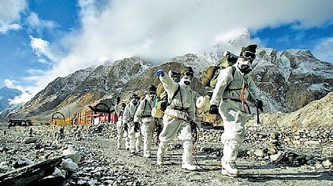
April 13 is an important milestone in global military history as India dramatically took decisive control over the Siachen glacier in the Himalayas on that day 40 years ago in 1984. It symbolises the gritty and determined deployment of the armed forces at the highest battlefield in the world - 20,000 ft above mean sea level - to protect the frontier despite heavy loss of human lives. Guns kept blazing every day from that day till 2003 when India and Pakistan agreed on a truce. Significantly, Siachen sits on the nuclear tri-junction of India, Pakistan and China. It’s the world’s only nuclear triangle.
Trouble began with the drawing up of a UN-brokered India-Pakistan ceasefire line in 1949 following the first war. The subsequent Karachi accord that year left the job of boundary delineation incomplete. The mutually accepted line was drawn only up to NJ 9842, which is the grid coordinates. From there, it said “thence north to the glaciers”.
Drawing the line straight north didn’t make sense as it would have cut through the glacier, frigid and icy rivers with changing contours and crevasses (deep crack in a very thick layer of ice) where deployment of forces and border patrol would anyway be difficult.
The correct interpretation of the ‘thence north’ phrase was to follow the natural features, which meant extending the line right up to the Indira Col along the Saltoro Ridge towards the west. That’s India’s position (see map). But Pakistan sought to twist it to mean it went further towards the northeast and terminated at the Karakoram pass. That interpretation would have swallowed the Siachen, which is the source of freshwater for the Indus river and much more.
Pakistan tried all its dirty tricks to snatch the glacier, even fighting an unprovoked war in Kargil in 1999 to sever Indian access to the Siachen. The glacier has strategic significance because Pakistan’s all-weather friend China is perched on the other side of Siachen, prepared as it is for the long haul. To illegally construct the China Pakistan Economic Corridor (CPEC) in Pakistan Occupied Kashmir (POK) in Gilgit-Baltistan, Beijing has deployed engineers of the People’s Liberation Army (PLA) and personnel of other construction companies there. Besides, China has moved in more than 60,000 heavily armed troops from Demchok up to Depsang in Eastern Ladakh along the Line of Actual Control (LAC) with India. The Chinese troop buildup is not very far from Siachen.
Place of roses
The word Siachen is an amalgamation of Sia and Chin, which in the local Balti language means place of roses. Wild rose shrubs can be seen at the snout of the glacier and in the lower valleys. Roses may symbolise peace and love, but bilateral frost is all you get at the glacier.
The Siachen glacier is 76 km long while its width varies between 2 km and 8 km as it juts into Gilgit-Baltistan. The glacier hangs at the snout towards OP Baba with Indira Col (named by the Workman expedition after goddess Laxmi, one of whose many names is Indira. The nomenclature has nothing to do with the then PM Indira Gandhi) at the northernmost point of the Saltoro Ridge.
With the changing international dynamics, the ground situation at the glacier acquired added significance because of its unique location. Growing military ties between China and Pakistan brought to India the very real challenge of a possible ‘two-front war’.
Operation Ababeel/ Operation Meghdoot
Pakistan’s claim line towards the east got a leg up after a US cartographic mischief when both were allies. Between 1964 and 1972, the US Defence Mapping Agency began depicting the truce line as extending from NJ 9842 to a point just west of the Karakoram Pass. Since the agency is an international reference point for cartography, it got ample traction and Pakistan used it for its eastward push.
In 1983, specific Indian intelligence inputs warned that Pakistan had begun planning an assault on the Saltoro Ridge to capture Siachen. Pakistan Army was preparing to push what it called the Burzil Force from Skardu under Operation Ababeel.
India countered it with Operation Meghdoot, suddenly dropping troops over most of the peaks and passes of the Saltoro barely 48 hours before the Pakistani operation got going. Indian soldiers occupied three critical passes in the Saltoro Ridge - Sia La, Bilafond La and Gyong La — blocking Pakistani attempts to enter the glacier. The Pakistani army was restricted to occupying the slopes and foothills on the west of the Soltoro. Indian positions are not visible from forward posts on the Pakistani side. Siachen lies to the east of the Saltoro and is lower than the ridge.

Monetary cost
As per recent estimates and official figures, around Rs 6 crore is spent every day to keep a brigade — around 5,000 troops — in Siachen. It works out to around Rs 22,000 crore annually. That is the price the nation pays for defending the nuclear tri-junction.
The cost to maintain troops and equipment at such an inhospitable terrain is definitely high. But the shift in the ground dynamics because of the presence of around 60,000 PLA forces in the Eastern Ladakh up to Y Junction in Ladakh — which is close to the important Daulat Beg Oldi (DBO) airfield — warrants such expenditure.
Harsh weather
Besides the military threats from China and Pakistan, the biggest challenge is from the elements. The temperature all through the year remains sub-zero and can even plummet to minus 60°C in the harsh winter. Besides, there is a constant fear of avalanches, crevasses and high speed wind. The rarefied atmosphere at the high altitude where the oxygen level is low, affects the soldiers both physically and psychologically. The effect of low temperature can lead to frost bites, chilblains (swollen skin, which appears several hours after exposure to cold), hypoxia (when oxygen is not available in sufficient amounts at the tissue level) and hypothermia (lengthy exposures to very cold temperatures use up the body’s stored energy, leading to lower body temperature).
Why is Siachen important
There are various factors that make Siachen a critical element in India’s strategic calculus. First, the glacier complex includes the Saltoro Ridge that overlooks the Gilgit-Baltistan area of Pakistan Occupied Kashmir (POK). Second, the ridge with high peaks guards the routes leading to Leh, the capital of Ladakh. Third, towards the north, it overlooks and dominates the Shaksgam Valley, which was illegally ceded to China by Pakistan. Fourth, it is close to the Karakoram Pass through which the Karakoram Highway passes, connecting Gilgit-Baltistan to Xinjiang province in China. And, last but not the least, Siachen is a wedge between Pakistan and China, not letting the two have linkup deeper towards the north of Kargil and Leh.
Chinese factor
The Chinese offensive mobilisation in Eastern Ladakh triggered a race to perch troops on the highest points across the region. The Indian Army’s experience in Siachen deployment helped them in reacting assertively and proactively to the Chinese provocation and expediting supply lines.
In the mid-1950s, China started its cartographic aggression on India - in Aksai Chin and the Pangong-Demchok sector of Ladakh. In 1963, Pakistan unilaterally ceded the Shaksgam Valley — that is visible from Indira Col — to China. Pakistan then started licensing western mountaineering expeditions to explore east of K2, including the Siachen. Sources say China has been basing its PLA personnel in the garb of road builders in POK and also influencing the administration there.
The China factor in the region was never discounted as the China Pakistan Economic Corridor (CPEC) is geographically close to the Siachen glacier. It got underlined as the Sub Sector North in Ladakh, the current flashpoint on the LAC.
The May 2020 skirmishes between the Indian Army and the PLA that led to massive deployment of troops and arms and equipment, shifted the ground realities. Among the stand-off points is Depsang, which is part of Sub Sector North. The terrain is such that large-scale armour operations are possible. China has multiple roads feeding this area while India has only the Darbuk–Shyok–Daulat Beg Oldi Road. At present, by sitting at the Y Junction, China can obstruct India’s movement. The Y Junction is about 20 km from the strategic Daulet Beg Oldi airfield. Depsang is also a link towards Siachen and the Daulat Beg Oldi airfield.
The airfield is adjacent the Chip Chap River and lies 8 km south and 9 km west of the LAC with China. The air distance to the Karakoram Pass from Daulat Beg Oldi is just 10 km, which is why the airstrip is of immense strategic importance. The average altitude in this terrain ranges from 14,000 ft to 18,000 ft. In addition, there are valleys and plains, which allow fast movement of vehicles.
Karakoram complex
Work on the Karakoram Expressway continues so as to strengthen communication between China and Pakistan. It is a multi-modal rail and road corridor that would also comprise an oil and gas pipeline. This is yet another example of China using geography for its economic benefit.
China has settled its border problems with its all neighbours excluding India and Bhutan. Ever since the 1962 India-China war, Bejing has been trying to encircle India from the North. The “deeper than Indian Ocean and taller than the Himalayas” Pakistan-China friendship needs to be kept in mind while trying to understand this region, including the Siachen region.
The China-Pakistan proximity has always been transactional. On 2 March 1963, Chen Yi, China’s foreign minister and his Pakistani counterpart Zulfikar Ali Bhutto signed at Peking an agreement which defined the “common boundary” between the two. Article 6 of the 1963 pact ceding the Shaksgam Valley to China said, “the two parties have agreed that after the settlement of the Kashmir dispute between Pakistan and India, the sovereign authority concerned will reopen negotiations with the Government of the People’s Republic of China, on the boundary as described in Article Two of the present Agreement, so as to sign a formal Boundary Treaty to replace the present agreement.” That agreement laid the foundation for the Karakoram highway, which was built jointly by Chinese and Pakistani engineers in the 1970s.
The Shaksgam Valley (trans-Karakoram tract) is part of the Hunza-Gilgit region of POK. It is on the border of China’s Xinjiang province to the north, the Northern Areas of POK to the south and west, and the Siachen glacier to the east.
India objected to the 1963 accord, saying Pakistan does not have a common border with China. India instead has the right over POK that borders China, as the then Raja Hari Singh formally acceded J&K to the country in 1948.
Demilitarisation
Various formulas for demilitarising Siachen have been floated but the problem lies in the trust deficit. Unless the border is clearly demarcated and accepted by all sides with full safeguards, any withdrawal of troops would give the adversary the opportunity to occupy the peaks and passes from where it would be difficult to dislodge them at a later date.
Some peaceniks who sought to convert Siachen into a peace park but it could not fructify. The revival of the idea in the near future is bleak due to Pakistan’s continued belligerence and the rise in the presence of Chinese troops in the region.