HYDERABAD: Pilgrimage is an aspect of faith where physical life comes in contact with the spiritual realm, leading to a sense of fulfilment or attributing finality to the physical life. Unlike the digital age where the experience of going on a pilgrimage can be recorded, captured and shared with a global audience, the documentation of pilgrimages in the past involved artistic expression that needed to be preserved across generations. There are paintings that depict devotees undertaking journeys that we now commonly know as yatras. These visual representations of the actual experience not only mark the geographical features but also talk about the more profound philosophies, meetings, and festivals that were celebrated during these journeys. Moreover, they themselves became a symbol of significance for those who could not participate in the yatra.
Prashant Lahoti, founder of Kalakriti India and also a map collector, shares some of these pilgrimage maps that can be roughly placed between the 15th to 20th centuries. Speaking at an event called Bharat Uvaach recently, he said these maps helped people to do darshan (visit the shrine of the deity) without physical travel.
What do pilgrimage maps portray?
“Pilgrimage maps have played a significant role in shaping the identity and culture of India. They are not only representative of physical spaces but also reflect how different religious sects view themselves. They show significant cultural and religious landmarks such as temples, sacred sites, architectural and historical characters as well as how creation is passed down from one generation to another. Pilgrims usually follow specific rituals along the route and they may also receive blessings from religious figures along the way,” said Prashant Lahoti.
Bridging the gap between physical and spiritual realms, these maps were based on oral traditions, verbally passed down generations by experienced pilgrims and guides. “The oral transmission of the explanation has ensured that the cultural and historical insights are preserved,” Lahoti added.
Not only the meetings and sites but also the festivals associated with them were highlighted through these maps. Also, they served as guides and provided information regarding certain neighbourhoods, temples, maths and dharamshalas to be visited and rituals that needed to be performed.
Darshan without travel
“These maps are frequently embellished with rich artistic representations such as paintings, drawings, symbols, demonstrations of cultural inventiveness and aesthetic expression but the most important use of this map has been liberation through darshan without travel,” said Lahoti.
Allowing a virtual recourse to these yatras, for those unable to participate in the journey, or remember the paths undertaken for a revisit, these maps also served as images of the deities themselves. “The image of the devta serves as a means to carry out the voyage by gazing. Just gazing at a deity serves as a means of gaining contact with it. As a result, looking at the map takes on the significance of religious experience,” he said. Sharing a few such maps from the Kalakriti Archives Collection, Lahoti sheds light on different types of yatras depicted in these maps.
Adwadeepa pata – cosmology maps
“The cosmology maps are parts of the Jain as well as the Hindu tradition. They represent the universe and its various components such as gods, demons and mortals. They also represent the physical and religious worlds as well as the spiritual journey. The Map serves as a guide for devotees to understand the spiritual merit associated with the pilgrimage to help people attain the goal of Moksha. This is why such maps are often called Adwadeepa pata or the painting of two and a half continents. In Jain texts, the universe is divided into three worlds.
The upper is occupied by the god, the middle by the mortals and the lower by the demons. The most significant is the middle world, the Manushya Loka. When liberation from the chain of rebirth is possible, the jinnas, the saints and the devotees are born. The world of mortals is abstracted as a diagram of concentric circles. The blue circle represents water while the gulf in between areas represents the land masses. The inner continent is encircled by two oceans and two further continents. The outermost land mass is encircled by a chain of mountains and shrines with sages or jinnas at the four quarters,” Lahoti explains.
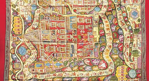
Satrunjaya Pata
Another map portrays the Jain pilgrimage of Satrunjaya patas, which is a pilgrimage circuit in Palitana, Gujarat. “The key purpose of these paintings is to provide a panoramic view of the shrines, the pilgrimage route and the significance, features and episodes that occur on a devotee’s path. They often serve as a surrogate for aged devotees who were unable to visit the site. They were displayed on the festivals on special occasions and were viewed by a large congregation of priests and devotees. The artist depicts the topographical context of Satrunjaya Hill with its two ridges. The first ridge is dominated by the main temple complex of Adinatha while the other is a setting of nine smaller temple complexes, patronised by the Jain merchants. The site overall comprises 65 temples, over 300 small shrines and is visited by close to 5000 deities,” he said.
Badrinath Yatra
Finally coming to one of the Char Dham Yatras, Lahoti shares the map of the Badrinath route. “These are three interlocked pilgrimage route maps, particularly the river Ganga and one of its chief headwaters, the Alaknanda, running from Haridwar up to the shrine of Badrinath in the Garhwal Hills.
These maps are read from left to right. The stroll is plentiful, comprising inscriptions, names, sacred places, villages, mountains and trees. The river Ganga is depicted as coming from the right bank and ends where Bhagirathi and Alaknanda meet at Devprayag. The pilgrims are shown bathing and washing their clothes. In the first scroll, the river branches out as it goes around Haridwar. Fortresses are located on both sides of the river. In the second section, it has a lot of temples and villages. The Narasimha temple is also depicted at Joshimath, where the deity is brought down before the temple is closed for six months due to heavy snow.
The yellow line through the map depicts a path taken by the pilgrims. To the extreme right of the third map is the Badrinath temple which is the final destination of the pilgrimage,” he explains. Concluding, he says that the maps provide bountiful information on the art and technology of different periods and how innovation took place over centuries.
