GIS, remote sensing to be set up with mobile app for Haridwar Mahakumbh
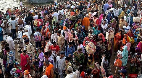
DEHRADUN: Upcoming Mahakumbh in 2021 in Haridwar will be put on Geographic Information System (GIS) and remote sensing will be set up to for better management of the mega event along with developing an android mobile application for the pilgrims coming to the Mahakumbh.
MPS Bisht, director of USAC said, "we are set for application and integration of technological tools for the convenience of people and the government. High-quality pictures, maps, rods and other geographical data will be collated for use of the public as well as the authorities".
Uttarakhand Space Application Centre (USAC) has taken up the task which will be first of its kind effort to manage any of the Mahakumbhs in the country, claimed USAC officials.
A letter has also been written by USACS to National Remote Sensing Centre (NRSC), Hyderabad for the procurement of high-resolution satellite imagery. Later, the data will be stored for a future application for such congregations and events involving larger populace.
The setup will be using satellite imagery which would enable the authorities to have real-time data for monitoring of the event. After getting fully developed, USAC will launch to develop a mobile-based application or app to facilitate the pilgrims coming to the Mahakumbh.
The plans are to integrate GIS-based data with the help of a dedicated support system to official website of the municipal corporation for accessibility of the same to government and public as per access rights.
The setup under this initiative which will have GPS enabled mobile phones integrated with GIS and remote sensing, the officials responsible for managing the event will be able to access would real-time information related to concentration of crowd, increase inflow and volume of water in the river Ganga, jams, or any other hindrance like occurrence to prevent it from transforming into a disaster.
The project is in the initial stage as the work for GPS based field survey to collect primary data for the geospatial database has concluded in January 2020.
Till date, data has been collecting data about restaurants, health centres, police stations, temples, railway stations, banks, government offices, fire station, road network, commercial shops and others.