GUWAHATI: A major environmental disaster is perhaps in the making in Arunachal Pradesh as a river system in the state has come to a virtual standstill following massive landslides and mudslides in the upper reaches.
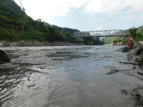
The landslides dumped millions of tonnes of mud and rocks into Kameng, substantially reducing the river’s flow. Its water in the East Kameng district has become like a muddy swamp instead of a raging river.
The river originates in the East Kameng district and is a tributary of the Brahmaputra.
East Kameng District Magistrate, Pravimal Abhishek Polumatla said during analysis and testing of the water at various locations, the district authorities found the total dissolved substance in the river to be very high and the dissolved oxygen to be very low. He said this could be the reason behind the deaths of a lot of fish and other aquatic animals.
“Four days on and the situation remains the same. The levels of turbidity and oxygen are more or less the same due to heavy mudflow. Prima facie, our understanding is that this is due to landslides in the upper reaches of the river,” Polumatla said.
He said as the actual cause could be ascertained through satellite imageries or aerial surveys, the state government was urged to help the administration get access to satellite imageries or deploy the officials of the State Remote Sensing Agency to do that part.
Environmentalist and a coordinator of South Asia Network on Dams, Rivers, and People, Himanshu Thakkar told The New Indian Express that satellite images had shown the incident was caused by landslides originating in one of the tributaries of Kameng which is a glacial tributary.
There are also glacial lakes there. This is the likely cause as of now behind this incident, he said.
“There has been no major earthquake in that region. Even in October, there was some rainfall in Arunachal. Snowfall in the higher reaches along with rain could have triggered the landslides or glacial-like outbursts,” Thakkar said.
The glacial area also has a lot of moraine debris. So, when there is a landslide or glacial-like outburst, a lot of debris flows down. This could be the cause of it, he said.
“A lot of studies are required to reach a conclusion but broadly it looks like related to climate change. Such kind of rainfall in October, accompanied by snowfall, is not usual in Arunachal,” the environmentalist said.
He said it was surprising that the mud was still there in the river. This should be finished by now, he said.
The East Kameng district authorities clamped Section 144 of the CrPC, prohibiting people from going to the river for fishing or other purposes as the high turbidity could cause incidents of drowning.
They restricted the sale and consumption of fish from the river for two weeks to avoid possible food poisoning. The administration deployed police personnel to patrol the river bank and urged community-based organisations to involve volunteers to sensitise people.
According to locals, the last such incident occurred 20-30 years ago.
