NEW DELHI: A low-pressure system in the Bay of Bengal has intensified into a cyclonic storm 'Jawad', the India Meteorological Department said on Friday.
The cyclonic storm is likely to reach the west-central Bay of Bengal off the coast of north Andhra Pradesh and Odisha by Saturday morning, the IMD said.
It will then move north-northeastward along the coast of Odisha and adjoining Andhra Pradesh and touch the coast around Puri by December 5 noon, according to the weather department.
Very heavy rainfall is likely to start in north coastal Andhra Pradesh and south coastal Odisha by Friday evening.
The intensity of rainfall is likely to increase on Saturday, it said.
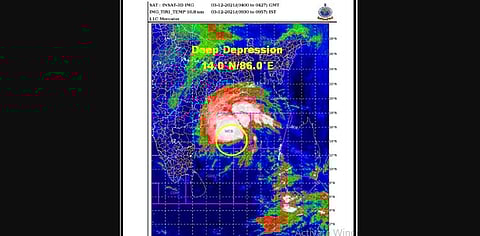
The low-pressure area had developed over the Andaman Sea on Nov 30.
It intensified into a depression on December 2 and further into a deep depression on Friday morning.
It turned in a cyclone on Friday noon, the IMD said.
A red colour warning has been issued for Andra Pradesh's Srikakulam, Vizianagram and Visakhapatnam districts for Saturday.
The red colour warning has also been issued for the Gajapati, Ganjam, Puri, Jagatsinghpur districts of Odisha. The name of the cyclone -- 'Jawad' -- has been proposed by Saudi Arabia.