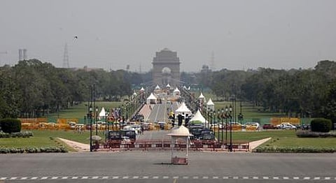

The revamped 3 km-long Central Vista will be inaugurated by Prime Minister Narendra Modi on Thursday. A lowdown.
OBJECTIVES
Refurbish and strengthen the landscape of the Central Vista Avenue
Provide amenities for civic users and tourists
Make it pedestrian friendly, easier to negotiate traffic
Provide adequate space and facilities for vendors
Ensure arrangements for national events cause minimal disruption
ALL THAT’s NEW
The project redevelops a 3-km-long Rajpath (now Kartavya Path) between Rashtrapati Bhavan and National War Memorial.
74 Historic light poles and chain links restored, upgraded and reinstalled on site.
100 White sandstone bollards installed to maintain the precinct’s historical character, replacing concrete bollards.
900 plus New light poles added along Rajpath, rows of trees, newly created parking bays, and the India Gate Precinct to ensure the area is always safe for visitors.
Rs 608-crore Project Cost
16.5 km Pedestrian walkways added along Rajpath, across the lawns, along the canals, and at the India Gate Precinct.
Pedestrian sidewalks along the Rajpath paved with robust and durable materials.
16 Permanent bridges built over the canals, making the space beyond the canals accessible for public use.
A part of the space assigned as parking bays for buses, two-wheelers, cars, app-based taxis, and auto rickshaws.
19 acres Total canal area refurbished and reinforced with necessary infrastructure like aerators.
Infrastructure such as stormwater pipes, power cables, transmission cables for Doordarshan, and other important conduits are consolidated in underground trenches enabling efficient and easy periodic maintenance.
GREEN COVER
101 acres.
Lawns are replanted with different species of grass, appropriate to their location.
Proper slopes and drain channels are integrated to minimise damage caused by the stagnating water.
Original Jamun trees preserved.
Existing trees surveyed and catalogued.
A comprehensive planting strategy was developed, based on the original formal planting pattern.
140 new trees already planted.
AMENITIES & FACILITIES
Eight new amenity blocks with vending kiosks and drinking water fountains were added along the Avenue.
64 Female toilets, 32 male & 10 accessible toilets added.
Seven Organised vending plazas.
Four New pedestrian underpasses at busy junctions to segregate vehicular traffic from pedestrian movement.
All amenity blocks and underpasses have ramps with railings at suitable heights for safe use by children and the specially-abled.
Stepped plazas at India Gate precinct.
REPUBLIC DAY PARADE
Modular bleachers are proposed for Republic Day seating arrangements, saving time and effort in setting up and dismantling, and reducing damage to the lawns.
Light poles fitted with necessary technology and services for the annual Republic Day Parade, connected to the newly laid underground service lines.
The Rajpath that wasn’t
When the layout of the British imperial capital in Delhi was being drawn in the 1910s, Edwin Lutyens, the architect of New Delhi, proposed a different alignment of the main or triumphal avenue now known as Rajpath. In the initial plan, the origin of the boulevard was Viceroy’s House proposed at Malcha village but it would terminate at the Jama Masjid in Shahjahanabad instead of Irwin Amphitheatre, which was later renamed as National Stadium after Independence.
However, Lutyens’ idea was not accepted by the Delhi Town Planning Committee set up in 1912 to plan, develop and design the new city. Later, the location of the Viceroy’s or Government House (Rashtrapati Bhavan) was also changed to Raisina Hills. Thus, the iconic Rajpath came into being.
The road, originally named as ‘Kingsway’, with sprawling lawns and water channels on both sides, India Gate and canopy is now referred as the Central Vista, the venue for the annual national celebration; Republic Day Parade during which military prowess and cultural pageantry is showcased.
After Independence, the avenue was given a new name—Rajpath. This historical stretch, about a three-kilometre-long road starting from Rashtrapati Bhavan to National War Memorial, has been redeveloped and will be unveiled by Prime Minister Narendra Modi in its new avatar as ‘Kartavya Path’ on Thursday.
How Rajpath evolved Over the years
Lutyens wanted to build palaces of Maharajas (rulers of princely states) along the ceremonial avenue along Rajpath with huge facades and imposing gates. But it was considered impractical and rejected.
Architecturally important, historically or culturally significant properties and places revered by the people were spared during the development of the site. Hence, Zabtaganj mosque standing at Man Singh Road—Rajpath intersection survived.
A golf club existed at the eastern edge of the site chosen for Rajpath facing Purana Qila. Lutyens shifted it to a nearby location. The relocated sporting facility is now known as Delhi Golf Club at Zakir Hussain Marg. The acquired piece of land was used to build India Gate and develop the Central Vista and Princess Park area.
While planning for the imperial capital in 1915-16, a proposal came up to allocate land close to Central Vista at Raisina Hills to build university buildings. But later, the DU campus came up to the north of Shahjahanabad.