NEW DELHI: North India is likely to see an early onset of winter this year owing to a spate of western disturbances. The Indian Meteorological Department (IMD) has forecast that a fresh series of western disturbances is likely to affect the western Himalayas and plains of northwest India from the weekend.
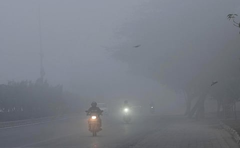
The early arrival of western disturbances brought down the temperature in Delhi. “On October 12, the minimum temperature in Delhi was 16.4 degrees Celsius, the lowest in the first half of October since October 12, 1962,” said Mahesh Palawat of Skymet, a private weather solution services provider.
Experts said the early arrival of western disturbance activities in October is a major reason behind early onset of winter. Normally, western disturbance activities start in the last week of October. “This time western disturbances arrived on October 9 and another scheduled phase of arrival is on October 15-16 and October 20-21 which will bring down the temperature,” said Palawat.
Western disturbances will cause snowfall on higher altitudes and north-westerly wind will bring down temperature, he said. Last year, there were negligible western disturbance activities. Western disturbance activities were activated in January 2023 which brought rains.
Western disturbances will bring light to moderate rain and snowfall is expected over Jammu and Kashmir, Ladakh and parts of Himachal Pradesh. Moreover, rainfall activities may increase over north Rajasthan, Haryana, Delhi, and parts of west Uttar Pradesh.
According to the IMD, a wet spell over Northwest India during October 14-17 is expected. Isolated heavy rainfall likely over Tamil Nadu and Kerala during the next 4-5 days due to development of cyclonic circulation over north Tamil Nadu.
In the meantime, the southwest monsoon has been withdrawing from eastern and southern parts. Withdrawal of southwest monsoon is seen from some more parts of Bihar, Jharkhand, Chhattisgarh; some parts of Gangetic West Bengal & Odisha; some more parts of Karnataka and remaining parts of Telangana, Maharashtra and Central Arabia.
The final withdrawal of the southwest monsoon is likely between October 20 and October 26. Northeast monsoon rains are likely to commence over southeast peninsular India during the same period. The IMD has forecast overall rainfall activity is likely to be normal to above normal over extreme south Peninsular India, plains of northwest India, central and adjoining east India and below normal over northeast India after October 20.
A cyclonic circulation lies over north Tamil Nadu & neighbourhood and a trough runs from this cyclonic circulation to Comorin area in lower tropospheric levels. It will increase rainfall activities isolated pockets of Tamil Nadu, Rayalaseema, and Andhra Pradesh.
