A new study published by Indian Institute of Geomagnetism (IIG) has demonstrated that the ionospheric disturbances generated even by moderate-sized earthquakes under magnitude 8 may show intricate rupture signals across multiple fault segments, instead of just from a single point near the epicenter of the quake. The finding could be used to predict earthquakes even before they occur.
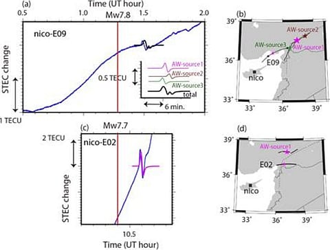
Scientists from the analyzed data from Global Navigation Satellite Systems (GNSS) tracking networks to model the coseismic ionospheric perturbations (CIP) triggered by the twin February 2023 Turkey quakes of magnitudes 7.8 and 7.7.
The ionosphere refers to a layer of the upper atmosphere about 60-1000 km above Earth’s surface, where ions and electrons are created by solar radiation. It influences the transmission of radio signals used in satellite navigation and communication. Coseismic refers to the timeframe during and after seismic activity. Acoustic waves generated by sudden crustal displacements during an earthquake propagate upwards into the ionosphere, producing fluctuations in electron concentration that can be detected as disturbances in GNSS satellite-receiver ranges.
The spatial analysis of CIP signals showed variability in amplitude and period of the ionospheric fluctuations for different azimuthal paths, which points to constructive and destructive interference of acoustic waves originating from multiple points along the causative fault, the study noted. Azimuth refers to the horizontal angle pointing towards a satellite.
In contrast, past studies using ionospheric perturbations for seismic characterization often assume simplistic point source models instead of extended ruptures spanning hundreds of kilometers across linked fault segments.
Surprisingly, the researchers also noticed longer duration and greater ionospheric perturbations amplitudes for the later M7.7 earthquake compared to the main M7.8 event.
The study attributed these differences to higher ambient ionospheric densities as well as probably distinct rupture extent and mechanics between the two quakes.
Besides illuminating earthquake physics like rupture velocities and slip distributions, the group envisions adding space-based ionospheric perturbations data from multiple GNSS constellations to traditional ground-motion monitoring networks for advanced seismic hazard analysis.
The future Atmosphere-Space Interactions Monitor distributed around the globe could provide complementary ionospheric variability data to improve model robustness.
Resolving the spatiotemporal evolution of fault ruptures through ionospheric sounding can provide critical lead time for disaster mitigation. Our future work will focus on developing precursor signals based on changes in the ionospheric trends prior to major earthquakes, the study noted.
The researchers also aim to apply interfereometric approaches combining GNSS and radar satellites to image subsurface changes for earthquake forecasting applications.
With the exponential rise of extreme seismic events, the novel ionospheric perspective demonstrated by IIG scientists could become an indispensable component of multi-hazard early warning systems worldwide. Integrating measurements across ground, atmospheric and orbital platforms can enable unprecedented tracking of strain buildup across active faults before massive quakes.
