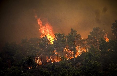
BHUBANESWAR: Forest fire has emerged as the latest threat to the lush, green expanse of Northeast India, often called the ‘Seven Sister States’. A new scientific study has revealed an alarming rise in the intensity of forest fires in this ecologically fragile region due to climate variability.
A team of climate and geospatial experts from India and Brazil have mapped over 3.6 lakh fire incidents across Arunachal Pradesh, Assam, Manipur, Meghalaya, Mizoram, Nagaland, and Tripura during 2001-2022 and analysed active fire points by using NASA’s MODIS satellite, linking fire patterns to climatic factors like temperature, rainfall, solar radiation, and wind speed.
Approximately 80% of annual forest fires were observed between March and April, with the years 2006, 2007, 2009, and 2010 marked by anomalously high fire incidences.
Fire events were predominantly recorded in woodlands, shrublands, regrowth areas, evergreen forests, and cropland mosaics. The highest frequency of fire occurrences was reported in 2009, contributing 7.40% to the overall. This was closely followed by 2006, which contributed 7.34%.
Among the Seven Sister States, Mizoram experienced the highest number of fire incidents, accounting for 24.2% of the total 3,60,383 incidents recorded during last two decades. It was followed by Assam (19.8%), Manipur (16.3%), Nagaland (11.8%), Arunachal Pradesh (9.1%) and Tripura (6.6%).
The study has identified a strong correlation between fire occurrence and climatic factors, particularly low rainfall and high solar radiation.
“It is a vicious cycle. As climate change intensifies, we see more extreme dry spells and hotter conditions, which in turn trigger more frequent and intense fires,” said lead researcher of the study Manoranjan Mishra, a professor of Geography at Fakir Mohan University.
The data revealed that March experiences the highest frequency of forest fires, accounting for 61.97% of the total recorded incidents. April follows with 18.13% of occurrences, and February with 10.12%.
The analysis showed a significant concentration of forest fires between January and April, with March witnessing the peak in fire incidents, comprising nearly two-thirds of the annual total. However, there is a silver lining. Since 2010, fire frequency has shown a slight decline, coinciding with a modest rise in rainfall and cooling in the region.
“This suggests that with better water management and early warning, we can reverse some of the damage," Prof Mishra reasoned. Fire prone Forest fires are increasingly recognised as a global crisis, causing extensive damage to ecosystems, biodiversity, and economies. It is estimated that approximately 420 million hectares of global forest areas are either burned or at risk of fire annually.
India experiences a higher incidence of forest fires compared to other Southeast Asian countries, with nearly half of these fires occurring in its northeastern region. Over 36% of the country's total forest area is fire-prone, with approximately 10% classified as highly susceptible.
The Seven Sister States, in particular, are recognised as highly vulnerable to forest fires. Forest fires in this region not only severely threaten its rich biodiversity but also disproportionately affect over 100 tribal ethnic communities, due to their socio-economic vulnerabilities.
Forests characterised as 'wood, shrubland, and regrowth, evergreen, mosaics with cropland' constitute the most extensive coverage, spanning approximately 58,717.65 sq km in the Seven Sister States. The 'evergreen mountain forest' covers 42,657.79 sq km and 'other land: mainly cropland and bare land, humid soils, inundated, flooded' areas amount to 42,271.22 sq km.
Among these forest types, the category 'wood, shrubland, and regrowth, evergreen, mosaics with cropland' was found to be the most fire-prone, with a total of 1,49,416 incidents, accounting for 42.46% of the overall fire events. This is followed by 'wood and shrubland deciduous, mosaics with cropland, which recorded 57,000 incidents or 15.82%, and 'mosaics of evergreen forest, fragmented or degraded evergreen forest, with 47,170 incidents, contributing to 13.09% of the overall fire events.
The study found 2006 saw the highest incidence of fires in the 'Wood, shrubland and regrowth, evergreen, and Mosaics with Cropland' forest type, with a total of 11,678 incidents.
Arunachal Pradesh, which has the largest expanse of 'Evergreen Mountain Forest' (37,166.95 sq km), also shows that these forest types are the most vulnerable to fires, with a total of 10,142 incidents.
A majority of the fires in Assam, Manipur, Mizoram, Nagaland, and Tripura were observed in a similar forest type. Causes and concerns The Seven Sister States region is distinguished by its ecological biodiversity, and due to its unique environmental characteristics, forest fires in this area are predominantly influenced by climatic factors.
In Northeast India, a distinct temporal pattern of forest fire activity has been observed, with a peak occurring from February to May. Exceptionally high number of forest fire events was recorded in 2009 accounting for 7.4% of the total incidents recorded.
The occurrence of forest fires is inherently driven by a variety of meteorological conditions, including wind speed, humidity and rainfall, apart from the solar radiation.
Rainfall, acting as a natural deterrent to fire, plays a pivotal role. During extended dry spells, the risk of fires escalates, whereas regular rainfall patterns tend to mitigate this risk.
Wind speed is another crucial factor, significantly influencing the rate and direction of fire spread. High wind speeds exacerbate forest fires by rapidly extending their reach, complicating containment efforts. In particular, 2009 and 2006 saw the highest number of forest fire incidents in the region.
Another author of the study, Biswaranjan Baraj said, when they juxtaposed the rainfall data, it was found that the recorded precipitation in these years -1,711 mm in 2009 and 1,490 mm in 2006 was below the study period's average annual rainfall of 1,943 mm.
"The study region witnessed the most frequent forest fires during the pre-monsoon season. The data suggest that climate change has a global impact on both the intensity and spread of forest fire events and rainfall serves as a significant influencing factor in the occurrence of forest fires,” he said.
During the study period, the lowest relative humidity levels were recorded in 2001 at 70.60%, followed by 2006 with 72.14%, 2002 with 72.59%, and 2009 with 74.36%. Interestingly, 2006 and 2009, which recorded relatively low humidity levels, also coincided with some of the highest forest fire occurrences. In the study area, the monsoon season typically exhibits the highest relative humidity levels, while the pre-monsoon season records the lowest.
Solar radiation, while not a direct causative factor, also played a significant role in influencing forest fire dynamics. It contributed to increased temperatures and the drying of environmental conditions, which are crucial in forest fire development. On sunny and hot days, particularly when accompanied by low humidity, conditions become favorable for both the ignition and spread of fires.
During the study period, the highest solar radiation level was recorded in 2009 (4499.8918 KWH/sq m/ year), and the lowest in 2015 (4311.55 KWH/sq m/year).
“Temperature is central to this dynamic, as it directly affects the flammability of vegetation. Higher temperatures can render vegetation more prone to ignition, thereby increasing the likelihood and intensity of forest fires. The insights derived from this study are invaluable for informing data-driven policy and strategy formulation for forest fire management in northeastern India. Understanding the interplay between climatic factors and forest fires is essential for developing effective prevention, mitigation, and management approaches, tailored to the unique climatic conditions of the region,” added Prof Mishra.
What needs to be done: Policy recommendations
The study puts forward several evidence-based policy recommendations to mitigate these growing threats
Climate-smart fire management
Governments should develop climate-informed forest fire models, using satellite data, wind patterns, and rainfall forecasts to predict high-risk zones.
Firefighting efforts can then be better targeted and timely Community involvement. Fire prevention can’t succeed without the local population. Programmes like Community Forest Watch can empower villagers to monitor fire outbreaks and manage land-use practices sustainably.
Ban on slash-and-burn practices
Traditional jhum (slash-and burn) cultivation, while culturally embedded, contributes to fire spread. The study calls for alternative livelihood support, such as agroforestry and climate resilient farming, to phase out high-risk practices.
Early warning systems
There is an urgent need for real-time fire detection using AI and remote sensing. Odisha and Maharashtra have already implemented app-based alerts like Damini and Forest Watch. Similar initiatives should be scaled across the Northeast.
Forest regeneration zones
The governments should demarcate forest fire recovery zones where post-burn rehabilitation, including native species planting, soil treatment, and fencing is carried out regularly.