DEHRADUN: As monsoon rains begin to envelop Uttarakhand, a stark annual reality unfolds for 115 families residing on 'Sri Lanka Tapu', a distinctive village nestled within Nainital district's Bindukhatta area.
Despite ambitious state-wide pushes for enhanced connectivity and modern infrastructure development, this community annually transforms into an isolated island, completely cut off from the mainland for three grueling months once the heavy rains begin.
In preparation for this predictable isolation, residents are already in full swing, meticulously stockpiling essential food and supplies. "We have to ensure we have enough to last us through the entire monsoon," explained Raghuveer Singh of Sri Lanka Tapu.
Rising waters during the monsoon make reaching the mainland extremely difficult and dangerous, compelling families to prepare well in advance to avert hardships during their prolonged period of disconnection. According to administrative sources, the number of members in 115 families in Sri Lanka Tapu is around 200.
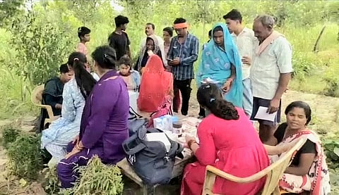
Acknowledging the unique and persistent challenges, Haldwani Sub-Divisional Magistrate Rekha Kohli recently visited the village, accompanied by various departmental officials. Acting on her directives, the food supply inspector distributed rations sufficient to last until August, while the health department provided a comprehensive three-month supply of life-saving medicines.
"We have ensured residents of 'Sri Lanka Island' receive crucial supplies to sustain them through the monsoon, including rations until August and a three-month supply of life-saving medicines to address their immediate needs," stated SDM Kohli.
Further bolstering emergency preparedness, a vital helipad has been constructed in Sri Lanka Tapu. Officials confirm this facility will serve as a critical lifeline, facilitating timely evacuation and treatment in medical emergencies and ensuring residents' safety during their isolation.
Known to its residents as Kalapani, the village earned its 'Sri Lanka' moniker from journalists who, during the devastating 1984 floods, likened its distinctive geographical appearance to the island nation when flying overhead.
Spanning 45 hectares, the village is uniquely surrounded by water on three sides and dense forest on the fourth, solidifying its status as a virtual island during the monsoon season and explaining its persistent isolation despite broader development efforts.