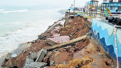

VISAKHAPATNAM: Thirty-one per cent of Andhra Pradesh’s coastline is eroding, 44 per cent is accreting, and 24.9 per cent remains stable, according to a report by the National Centre for Coastal Research (NCCR).
The report, titled ‘Management of Coastal Erosion along Andhra Pradesh - Shoreline Change Atlas of Andhra Pradesh,’ provides a detailed analysis of erosion and accretion patterns along the State’s 1,027.5 km-long coastline. The study, covering the period from 1990 to 2022, indicates that 318.96 km of the State’s coastline have experienced erosion, 256.32 km remain stable, and 452.3 km are under accretion.
While erosion means the land near the sea is being worn away by waves, currents, and storms, accretion means the opposite. An expert in the subject explained that accretion means the build up of sand and sediments, creating new land. However, this could be both good and bad. In Andhra’s case, accretion is not necessarily bad on its own, but must be carefully managed. If it leads to an imbalance, like worsening erosion elsewhere or affecting local livelihoods and ecosystems, it could become problematic. Sustainable coastal management can help balance the benefits and risks.
The study, conducted using Resourcesat-2 and LISS-IV satellite data, excluded river and creek areas and focused on the shoreface length.
Study lays emphasis on shoreline mapping
It highlights that coastal erosion is a significant concern in certain districts. West Godavari recorded 52.5 per cent erosion, while Kakinada reported 52.8 per cent. Krishna district followed with 43.8 per cent erosion.
On the other hand, accretion exceeded 50 per cent in Anakapalli (56.7 per cent) and Vizianagaram (54 per cent). Most coastal districts in the State have shown an accreting trend over the last 32 years.
The study categorises the 1,027.5 km coastline into seven segments based on erosion and accretion levels. It noted that 91.96 km falls under ‘high erosion,’ 39.64 km under ‘moderate erosion,’ and 187.7 km under ‘low erosion.’ Additionally, 256.31 km is considered stable, while 281.72 km falls under ‘low accretion,’ 57.78 km under ‘moderate accretion,’ and 112.8 km under ‘high accretion.’
“Hard structures such as seawalls and groynes have been widely used for protection, but their long-term impacts on sediment transport and beach morphology are raising concerns. Soft solutions like beach nourishment, which involves replenishing sand on eroding beaches, are gaining popularity as sustainable alternatives,” the report stated.
The study emphasised the importance of mapping shoreline changes regularly to develop precise measures for coastal protection and management. NCCR has been monitoring and analysing shoreline changes across India under the Coastal Processes and Shoreline Management (CPSM) project since 2013. This ongoing effort aims to provide updated and reliable data for effective coastal management, ensuring the safety and sustainability of coastal regions.