BENGALURU: Researchers from Indian Institute of Science, Bengaluru have released a report and announced the launch of the Western Ghats Spatial Decision Support System (WGDDSS) which shows the status of the ecologically sensitive regions.
One of the co- authors Prof TV Ramachandra, from Centre for Ecological Sciences, told TNIE that for the first time people, activists and even government officials will be able to see the ground situation of the forests, especially the rapidly degrading Western Ghats. On the web portal, viewers can see the region-wise and grid-wise live visuals of the Western Ghats, he said. This information will help in planning as per Biodiversity Act 2002.
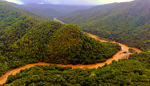
As per the preliminary findings of the report, using temporal remote sensing data, serious concerns have been highlighted on the status of forests and conservation options. Deforestation and mismanagement is evident and the current extent of forest ecosystems which have been threatening water security.
The WGDDSS will help to visualize the regions based on eco- sensitiveness, the variables used for computing eco- sensitiveness and aid in decision making at decentralized levels (including municipal council, local forest department etc.)
The study was undertaken by Prof Ramachandra along with Bharath Setturu, Vinay S, M D Subash Chandran, Abhishek Baghel and Bharath H Aithal.
Researchers said the spatiotemporal analyses of land use highlighted the anthropogenic induced developmental thrust which caused a loss of 5% evergreen forest cover with an increase of 4.5% built-up cover and 9% agriculture area.
“Fragmentation analyses highlighted that interior forest constituted only 25% of the forest landmass. It depicts the fragmentation pressure and impact of local ecology. A Grid wise analysis showed that 32% of the area under ecologically sensitive region (ESR) has been denoted as very high ecological fragility. The ESR analysis depicts 63,148 sqkm area under very high ecological fragility and 27,646 sqkm area as high ecological fragility,” said TV Ramachandra.
The report also showed that 48,490 sqm is moderately sensitive and 20,716 sqkm has been marked as low in ecological fragility.
