BENGALURU: No technological interventions are perfect, and there are always some grey areas. This is true of satellite images and data accessed by the Karnataka Forest Department to manage forest fires.
Along with strengthening ground staff by hiring more contract employees for forest fire management, the department has also been relying on technological interventions.
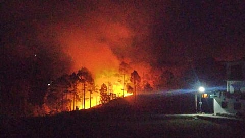
It takes images for alerts from satellites of National Aeronautics Space Agency (NASA) of the United States and Europe. But no satellite imagery and data are available from 3.30 am to 10.30 am, and from 3.30 pm to 10.30 pm. The forest department calls it the ‘blind period’.
“There is no satellite data on forest fires for almost 14 hours a day. This is crucial. To address this, we are requesting governments and space research agencies for help, especially now as it is a drought period and there is an early onset of summer. The available detection window is from 1am to 3.30 am, 1 pm to 3.30 pm, 10.30 pm to 11.30 am and from 10.30 pm to 11.30 pm. During the blind period, we rely completely on ground staff,” said a senior official from the fire detection and management wing of the forest department.
From January 1 to February 1, the forest department received 1,491 alerts, of which 936 were fire incidents and the remaining were creation of fire lines (controlled burning).
“Since we are expecting more incidents of forest fire this year, we are working on moisture stress analysis. Satellite images are being used to prepare normalised density vegetation index. The moisture content in the air and grass is assessed and compared with data of last week and even last year, using satellite images.
Based on this data, ground weather reports are included in the assessment, after which a list of vulnerable locations is prepared. This data is also helping in the creation of fire lines,” said Additional Principal Chief Conservator of Forests Bishwajit Mishra.
This year, the department is also assessing fires in 500m buffer areas of forests. “We are using this information as there are chances of fires spreading inside forests. Ground staffers are given alerts to check, douse, and submit a report on the server,” Mishra said.