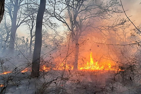
KARWAR: Every summer, the Karnataka forest department is on its toes to douse forest fires, especially in protected zones. Flora and fauna become ritual offerings. Forest fires have economic, social and environmental impact, and the forest department has a long way to go to make it a fire-free year in the state.
According to scientists, human activities are responsible for 75 per cent of forest fires. Forests Minister Eshwar Khandre told the Legislative Council recently that there were 87,228 forest fire incidents in the state between 2021 and March 2026. In 2023, there were 23,685 incidents and in 2024, the numbers came down to 11,163.
RK Somashekar, former head, Department of Environmental Science, Bengaluru University, says that 99 per cent of forest fires in Karnataka are man-made. “There is no such thing as a natural fire,” he says. In 2008, he conducted a study on forest fires in Bhadra Wildlife Sanctuary (now Bhadra Tiger Reserve). Somashekar found that villagers were setting alight dry, dead bamboo in Muthodi range, in Bhadra Wildlife Sanctuary.
The height of the bamboo enhances the vertical spread of fire, resulting in a crown or canopy fire, the study pointed out. Somashekar says fire risk areas are dominated by moist deciduous and dry deciduous bamboo. More than 35 per cent of slopes near settlements and less than 100 metres from roads fall under high degree of fire risk, while moist, dry deciduous and bamboo within 1,000 metres of settlements, 100 to 200 metres from roads, and 5 to 10 per cent of slopes are at medium risk of fire; those falling 200 to 300 metres away from roads, and 1,000 to 2,000 metres from settlements fall under low risk of fire.
“Agriculture and plantations 2,000 to 3,000 metres away from settlements, 300 to 400 metres away from roads do not face any fire risk at all. This is because these properties are managed by farmers themselves,” says Somashekar.

Who lights the fires?
The state has 38,284km of forest area -- 5 per cent of the total forest area of the country, which includes tiger reserves such as Bandipur, Nagarahole, Bhadra, Kudremukh, Kali and BRT Tiger Reserve, and several wildlife sanctuaries.
However, the protected areas prone to forest fires are Bandipur Tiger Reserve, Nagarahole Tiger Reserve, BRT Tiger Reserve and Cauvery Wildlife Sanctuary, which are mostly scrub, dry deciduous and moist deciduous patches harbouring crucial Schedule 1 animals like tiger, elephant, leopard, dhol and herbivores like Indian gaur, chital, sambar, mount jack and other animals. “Most of these forests have very rich flora and fauna.
There have been selective fires in these forests. Villagers in the fringes and poachers and small-time smugglers who decamp with poached materials and timber are the culprits,” says Somashekar. He suggests intense awareness campaigns and the need for working with locals by providing them a good living and taking them into confidence to prevent forest fires.
“The forest department should rope in Doordarshan, All India Radio and other media to educate people about the impact of forest fires and announce rewards to locals to inform about miscreants who set fire to the forest. The department should mark fire-prone areas and have an integrated forest fire prevention network using the latest tools to detect fires, and also have a rapid response team,” says Somashekar.
Kumar Pushkar, Principal Conservator of Forests and Chief Wildlife Warden, says every year the department begins fire prevention exercises from the first week of December. “Wildlife areas are prone to fire accidents and we put in maximum effort to prevent fires. We start marking fire lines (controlled burning).
We recruit fire watchers to the Protected Areas. We have identified sensitive areas and the staff is deputed to vantage positions so the entire forest is visible. In case of fire, they alert the ground staff who get into action,” he says. Pushkar says the Fire and Emergency department has been giving frequent training to forest staff and watchers.
Soil factor
According to a study published in the International Journal of Research in Agronomy, ‘Studies on Impact of Forest Fire on Physical and Chemical Properties of Soil Under Different Vegetation Types in Uttara Kannada district’, dry deciduous forest patches -- most of the forests of Bandipur, Nagarahole,
Cauvery Wildlife Sanctuary -- are prone to fire accidents, followed by moist deciduous forests and tropical semi-evergreen forests. The study by researchers Raji J Mohan, Forestry College, Sirsi; UAS Dharwad, and Gopal V Dasar, Professor Soil Science, Forestry College, Sirsi, and others aimed at finding impact on soil in select dry deciduous forests, and moist deciduous forests of Dandeli and Banavasi found there was severe loss of soil nutrients in the dry deciduous area.
The traditional method of dousing fires has affected forest staff and taken a toll on them. In February 2017, 28-year-old forest guard Murigeppa Tammagol died while fighting a forest fire in Kalkere range of Bandipur Tiger Reserve.
According to the postmortem report, he died due to asphyxiation and severe burns as he was caught in thick smog while dousing the flames. He was a deputy range forest officer at Moleyur range in Bandipur.
A range forest officer and a few others were also injured in this incident. Six years later, on February 18, 2023, another forest guard, Sunderesh, died of burns at Kadumane in Sakleshpur, and other staff members were injured. These incidents indicate that the forest department needs to use state-of-the-art facilities and adopt more care and caution while extinguishing fires.
“Fighting fire in the dry deciduous tracks of the Western Ghats is challenging. With a rise in global average temperatures, it is more difficult to put off fires in burning lantana and other invasive species. Forest staff should be more vigilant to prevent blazes, and protection measures in the pre-fire season are key.
Old fire lines, which are covered with invasive species and forest growth, must be maintained. Sometimes, it may require cutting down grown trees. But when a fire becomes uncontrollable, helicopter services should be made available for pouring water from the top,” said BK Singh, retired Principal Chief Conservator of Forests.
“We appoint fire watchers to douse fires. The traditional method of extinguish a fire is beating it with bushes and gunny bags. We have now provided them with blowers. They are effective in stopping the spread of flames,” said Kumar Pushkar, Principal Chief Conservator of Forests and Chief Wildlife Warden.
He said the staff is trained in how to be alert in case of extreme fire and smoke. “They are told to cover themselves with soaked clothes. They are provided water to keep themselves hydrated. There are chances of people collapsing in case of a big fire and smoke,” he said. “We also provide water sprinklers and other equipment which help tame the fire immediately,” he said.
But with the fire incidents continuing, locals blame the authorities for diverting staff to civil works than marking fire lines and clearing vegetation.
RK Somashekar, former head, Department of Environmental Science, Bengaluru University, is advocating the extensive use of remote sensing satellite images for addressing the issue of forest fires. He says satellite remote sensing provides practical means of monitoring and acquiring information about spatial distribution of fore scars and fore activity.
“Understanding the behaviour of forest fires, factors that contribute to making an environment fire-prone, and factors that influence fire behaviour are essential for forest fire risk zone mapping,” he says. GIS and IRS provide necessary tools to map hazardous fire incidents.
In a scientific paper, ‘Application of Remote Sensing and Geographic Information System in Mapping Forest Fire Risk Zone at Bhadra Wildlife Sanctuary’ authored by him and another researcher, SV Sowmya, he says images were converted into android data and superimposed on maps to draw the fore maps.
“There was a field visit to confirm the accuracy. We tried this in Bhadra and Bandipur and confirmed the accuracy of the images. The area of the fire, date, time and extent of damage caused can be analysed. We did this in 2010, when we used to get images of 36x36 metre pixels. Now technology has changed drastically.
We get data from IRS and other data, where we get a resolution up to 1x1 m pixels,” he says. The forest department should have an integrated forest fire prevention network where an expert should work on extracting remote sensing data and channelize it to places across the state, mapping places vulnerable to forest fire.
“This should be a constant process, not working just for three months of fire season. Data should have details of the previous image, fire time reports and post-fire incident to assess the damage,” he said.
Khandre said the department, with support from Karnataka State Remote Sensing Application Centre, will monitor fire alerts.