
KOCHI: Traditional farmers are usually averse to technology. But in the face of adversity, cutting-edge technology has come handy for a group of farmers in Malappuram district to understand the looming threat and launch an agitation.When the Union Ministry of Environment and Forest issued the draft notification declaring 148 sq km land around the Silent Valley National Park as eco sensitive zone, farmers were not aware of its impact.
The forest department had maintained that new restrictions will not affect farmers. However, they managed to secure a map of the eco sensitive zone with the help of A P Anil Kumar, MLA. As the map did not have any physical landmark on the extent of land coming under the zone, they were left in the lurch.
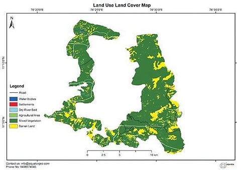
This is when a remote sensing firm came to their aid. Equator Geo Pvt Ltd, a startup founded by three MTech graduates from the Indian Institute of Remote Sensing in Dehradun, used to digitise the map with the help of geo coordinators. They used satellite images to identify the physical boundaries of the eco sensitive zone.
The 10-day-long survey helped prepare a land cover map, which revealed that 36,556 acres of human habitation located in 12 villages of Malappuram and Palakkad districts were included in the eco sensitive zone.
“Though the protected area of the forest is only 79.52 sq km, the forest department has brought 148 sq km of land under the eco sensitive zone. The zone extends from 2 km to 9 km from the forest boundary according to the terrain. The map is in public domain and anyone can check it,” said Josy Jacob, an advocate in Malappuram, who fights for farmers’ rights.
“The state government had informed the Wildlife Board meeting on January 28 that there was no objection from the farmers and the expert committee can go ahead with the procedure for the final notification on eco sensitive zone for Silent Valley National Park. The authorities never discussed the issue with the farmers and have been reiterating that it will not affect us. But the geographic mapping revealed that around 3,000 farmers will be affected,” said Kerala Independent Farmers Association (KIFA) Malappuram district president Mathew Sebastian.
“We launched the firm six months ago. But we have implemented 14 projects and have secured two patents. Our applications range from crop monitoring to urban planning and disaster management. Hailing from an agrarian family, I could understand the farmers. A team of seven members strived for 10 days to prepare the map,” said Jais Jose, CEO of the firm.
No human settlements included: Forest dept
Refuting farmers’ allegations, the forest department said maximum care has been taken to exclude human habitations from the zone. “In the eastern side there is about 100 acres of revenue land at Chindekki under Bhavani Range of the Silent Valley Division. The area is surrounded by forest on four sides. Around 50 per cent of the inhabitants are tribal people and 50 families are settlers. The area falls under Kallamala village of Palakkad district,” said an official.
The North-Western boundary of the eco sensitive zone comes under the Silent Valley National Park Range. There are two revenue enclosures that falls under the boundary of the buffer zone in Chokkad village of Malappuram district. The place is surrounded by forest on all sides.
One enclosure has 49 acres of farm land while the other has 159 acres. These are plantations and there is no settlement area, said the f orest minister’s office.
Boundaries of Silent Valley National Park eco sensitive zone
North
The eco sensitive zone runs along the interstate boundary from Kottappuzha. The width ranges from 4.75 km to 5.3 km
North east
Melethudukki Bhavani river. Width: 4.3 km to 6.3 km
East
From Kadukumana South along Bhavani river towards south. Width: 4.5 km to 6.3 km
South East
Along the banks of Bhavani river till Mandanpottithodu, moves west along southern boundary of Attappady up to Thathengalam in Mannarkkad. Width: 3.2 km to 9.8 km
South
From Thathengalam to Vanampara. Width: 0.5 km to 2.6 km
South West
From Vanampara to Kannampally in Malappuram district. Width: 1.75 km to 5 km
West
Kannampally to Atti. Width:
1 km to 3.1 km
North West
Atti to Kottappuzha Width: 1.3 km to 3.3 km