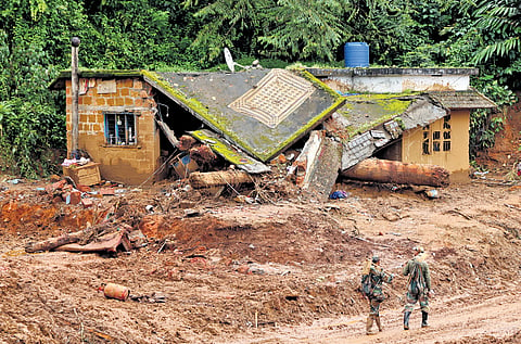

KOCHI: Can landslides be predicted hyper-locally, thereby preventing huge loss of lives? The question becomes pertinent in the wake of the Wayanad landslides amid reports that the authorities may have ignored warnings about an impending disaster following the forecast of heavy rain in Mundakkai, the epicentre of the devastating natural calamity.
While a prediction with precise accuracy is near impossible, experts working on the ground in Wayanad reckon warnings can be issued to the residents in the landslide-prone areas after analysing micro-rainfall data. Along with the micro-rainfall data, close tracking of the cloud movement pattern and an analysis of the wind and its wind speed would go a long way in more accurate and actionable forecasts on landslides, thereby saving lives, say experts.
After the 2019 flood havoc claimed 17 lives at Puthumala in Wayanad, 200 rain gauges were set up across the hill district with the help of local farmers and groups to record micro-rainfall data in a move to prepare the people on rainfall-related havoc. This had an effect when the authorities evacuated people when 55 rain gauges recorded 1,000mm rainfall within a short period in and around Mundakkai. While several houses were destroyed, there were zero human casualties as hundreds of people in the area were shifted to safer places.
This time too, the warnings were issued, but there are criticisms from several quarters that the district administration may not have communicated the dangers to the people effectively. “After the heavy rains and warnings issued, there may have been some complacency among the people as the rains stopped and the sun came out on Monday (it rained heavily that night and the landslide occurred early Tuesday),” explains Deepa C B, assistant director (soil survey), Wayanad.
But after the catastrophic landslide swept away Chooralmala, Attamala, and Mundakkai villages in Wayanad, there will be more focus on this people-centric forecast model.
“Ours is a simple logic. If such a large amount of rain comes in an unstable slope, there are high chances of a landslide. If we can create awareness among the people living in the area, we can shift those people to safer places. Sometimes, a landslide may not occur. But we can predict with 70% accuracy about landslides,” says Dr Suma T R, scientist at the Hume Centre for Ecology and Wildlife Biology, Kalpetta.
The Hume Centre is playing a crucial role in Wayanad’s community-driven climate monitoring system. Every morning, farmers and other volunteer groups put the rainfall data collected at 7am into a specific WhatsApp group. The data is analysed by the experts at Hume Centre and they provide the forecast/warnings to the district disaster management authority (DDMA). Extremely high rainfall triggered by climate change is the cause of these landslides, says Hume Centre Director C K Vishnudas.
“We cannot predict landslides and extreme, sudden rain using the normal forecasting methods. However, using the radar images and by finding the patterns of clouds, including their thickness, we can detect where and in which direction they are moving,” Vishnudas says.
The Hume Centre has tied up with the Advanced Centre for Atmospheric Radar Research at the Cochin University of Science and Technology to get a forecast. “The rain observation is posted on the WhatsApp group and the Hume Centre moves the data on to a grid (the district is divided into grids and each of the grids has rainfall-monitoring stations). Based on that, I generate a forecast. We give 70% accurate predictions on which they can take action. I provide this data to the Hume Centre in my individual capacity,” says Dr S Abhilash, director, Adv ofanced Centre for Atmospheric Radar Research. He points out that cloud and wind movement patterns can also be easily tracked and monitored, based on which landslides can be predicted with 70% accuracy. “We even have three-four papers on the cloud movement pattern. We can save lives using the data by relocating people,” Dr Abhilash says.
“Based on radar images, we can observe the clouds the next day. We can give a yellow or orange alert one day in advance. If the clouds are developing deeper, we can warn people to move away. We can develop a system,” he addsIf an antecedent rainfall observation cell is in place, they can go ahead with a decision-making process, he says. “Coupled with this, if we have these forecasts at our disposal, the prediction will be more accurate and actionable.”
Another scientist, who wishes not to be named, stresses that a people-centric early-warning system is the need of the hour, which was suggested back in 2017 after the Ockhi disaster. “We should move ahead with the available resources at our disposal to develop a system. It would be the best example of a Kerala model,” says the scientist. “In a formal system, we cannot ignore the IMD and give weather predictions simultaneously. What the government did was get weather data from private agencies such as SkyMet and IBM Weather. Instead, we should develop our system, which will supplement the IMD. IMD has its limitations. However, we cannot release these data and findings to the public, but we can use them for our internal consumption,” the scientist says.
MORE ACCURATE METHODS
Experts working on the ground in Wayanad reckon warnings can be issued to the residents in the landslide-prone areas after analysing micro-rainfall data
Close tracking of the cloud movement pattern and an analysis of the wind speed could provide more accurate forecasts on landslides