CHOORALMALA: Laying fears of a possible repeat of the devastating landslide at Vellarimala, which swept away the hamlets of Punchirimattam, Mundakkai and Chooralmala on July 30 last year, earth scientist John Mathai has said that chances of such an eventuality are slim.
A retired scientist with the National Centre for Earth Science Studies, John had led a six-member expert committee formed by the state government to study the causes and impact of the landslide, visiting the source of the landslide and studying the behaviour of debris flow.
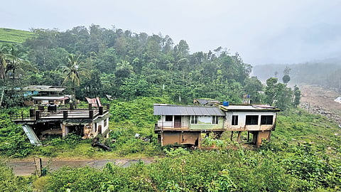
Earlier, the district administration had said there is a huge deposit of debris upstream, and hence, a heavy rain could trigger a debris flow capable of washing away the Bailey Bridge.
“There is some debris brought down by the landslide on either side of the river,” John told TNIE.
“The river will wash away the soil over a period of time and the boulders will remain. Even if there is heavy flow, it won’t extend beyond the danger zone marked by the expert committee. Chooralmala has a 10-feet high sand deposit that has to be removed. The Uralungal society has cleared the debris on the riverbed at Chooralmala and constructed a side wall to smoothen the flow of the river. There is no material at the source of the landslide that can trigger a debris flow.”
He said there has been a change in the pattern of landslides after the extreme rain of 2018. Landslides before that were events that led to the detachment of earth from the up-slope part and its redistribution on the lower slopes, often within a kilometre from the point of origin. However, in Puthumala (2019), Pettimudi (2020) and Chooralmala (2024), the source point was in a forested area and the material was transported to a few kilometres along existing stream channels.

“These events also involve the removal of overburden and the widening of river channels, wiping away all man-made structures in the immediate vicinity of both banks,” he said.
John recommended a micro-level survey marking specific locations where landslide initiation can occur. The area received 372.6 mm rainfall on July 29 and the precipitation on the previous day was 200.2 mm.
“The source point of the landslide was located about 1,500 m above mean sea level on the north-facing slope of Vellarimala hill ridge where many first-order streams confluence to form the Punnapuzha river.
The material was carried down by the flood waters of Punnapuzha eroding both the banks and depositing it on the lower reaches stretching up to Soochippara. The total area of inundation and destruction was about 110 hectares. The material included large blocks of weathered rock and reddish soil. The thickness of the failed column varied from three to five metres,” he noted.
The high-water mark in the river channel exceeded 20 metres from the riverbed at least in three locations, like Vellolippara waterfall, Punchirimattam bridge and Seethammakundu waterfall.
“This could only be due to boulders and tree trunks forming temporary dams blocking the river channel,” John said.
The breaching of such dams added to the velocity of the flow of debris-laden water. The peak velocity of the river after the landslide is estimated at 82 m/second at Punchirimattam and Seethammakundu near Mundakkai and 57 m/second at Chooralmala bridge. At this velocity, material from the crown region is expected to reach Chooralmala bridge within two minutes, he pointed out. The total mass removed from the crown till Mundakai LP School was about 25 lakh cubic metres.
The expert committee has recommended the government to avoid habitations in areas marked unsafe. To relay the road from the Vellarmala VHSS to Padavetty, the government has to raise the embankment.
“As that isn’t viable, the authorities should consider extending rehabilitation to the families living there,” the committee noted.
The bridge at Chooralmala, along with the approach road, should be elevated by at least 2.5 metres from the current road level to prevent any form of submergence. The committee also recommended elevated foundation for structures in Chooralmala town.
The panel recommended restrictions on levelling of ground for the construction of houses at places where the slope is more than 25%. Ponding of water, contour bunding, terracing, tilling, construction of roads and houses, etc at places where the slope is more than 25% cannot be permitted.
Recommendations
A micro-level survey marking specific locations where landslide initiation can occur
Avoid habitations in areas marked unsafe
Elevate the bridge at Chooralmala, along with the approach road, by at least 2.5 metres from the current road level
Elevated foundation for structures in Chooralmala town