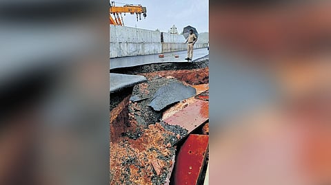
THIRUVANANTHAPURAM: The recent caving in of roads and crack formations on several stretches of NH-66 in the state are the result of the failure of NHAI to identify susceptible sectors and implement site-specific engineering solutions.
The Geological Survey of India, Kerala unit, which carried out a prima facie site assessment during September 2024 at Bevinchi, Thekkil, Veeramalakunnu and Mattalayi hills in Kasaragod where NH-66 road extension works and excavation was under progress had warned about probable landslides along the cut slope as ‘moderate to high.’
Incidentally, it was very near to the study area at Mattalayi, near Cheruvathur, that a hillock collapsed during construction resulting in the death of a person, and leaving two others injured on May 12. According to the GSI study, the soil thickness and composition vary significantly throughout the road stretch. The susceptible sectors should be identified, and site-specific engineering solutions should be implemented based on on-site situations. A detailed study must be carried out on the stretches, the GSI study had recommended.
The study was carried out by GSI after the Kerala Disaster Management Authority (KSDMA) asked the former to conduct a study on the particular stretch. The Kasaragod district collector had approached the KSDMA to conduct a study after complaints against construction lapses were evident. After the study report was submitted, KSDMA asked NHAI officials to intervene in the issue. However, NHAI officials ignored the directive.
The report further said that landslides are caused by inappropriate slope cut for NH-widening activities, the removal of overburden material, significant rainfall and water saturation. “Multiple landslides, and debris slumps occurred in the cut slopes during NH widening. The cut slope exposes thick silt and clay soil cover and laterite cover, which lie over charnockite and Hornblende biotite gneiss rocks.
The laterite layer is not sufficiently strong to sustain the current overburden slope profile, resulting in collapse. A thorough assessment of the zone is recommended to assess possible slope stabilising solutions for individual stretches with respect to the slope forming material types and slope angle,” the report said.
It also revealed that horizontal drainage on most hills were obstructed. “Field study revealed that the evidence of slope instability ground signatures such as debris slide, slumps, tension cracks, transverse cracks, tilted trees, and seepages were evident. It needs to be studied in detail,” the study recommended.
In the pre- monsoon preparation meeting convened by the chief minister on May 16, KSDMA raised alarm signs about the possible issues in NH-66 going through Kasaragod, Malappuram, Kozhikode and Alappuzha districts.
“The KSDMA suggested that a rapid response team be formed to address the issues that are likely to occur during monsoon. The issue also reveals how national agencies ignored the demand for disaster risk reduction. NHAI failed to do it. In any engineering design, three per cent of investment cost must be set apart for investigation. The design of the project comes second,” a KSDMA official said.
“A geo-technical study must be carried out even before the land acquisition for the NH,” a GSI official told TNIE on condition of anonymity. “In Kerala, the terrain is different on each stretch. Hence one study is not enough. We have to study the topography, geomorphology, geology and nature of soil on each stretch from Kasaragod to Thiruvananthapuram,” he said.
Highlights of GSI study
The soil thickness and composition vary significantly throughout the road stretch
The susceptible sectors should be identified, and site-specific engineering solutions should be implemented based on on-site situations
A detailed study must be carried out on the stretches
Though the NHAI had signed an MoU with GSI on January 31, 2024, as part of the construction of NH-66, the central agency did not approach the GSI before starting the work.
