BHUBANESWAR: Every time there is a cyclonic storm along the coast of Odisha, the high definition Doppler Weather Radar (DWR) of Defence Research and Development Organisation (DRDO) comes to the rescue of the India Meteorological Department (IMD) and State government in terms of weather updates.
This time though, the government and IMD failed to get the much required DRDO updates as the Doppler radar has been lying defunct for over six months. The radar located at the Integrated Test Range (ITR) at Chandipur-on-sea is capable of monitoring a cyclonic system 400 km away (300 km away with clear vision).
It not only generates data that help the weathermen to predict the intensity and path of the cyclones, but also saves life and property due to early forecasts. The DRDO, which has two strategic units along the coast, now depends on the IMD.
"Unlike the earlier systems, Yaas has been behaving unexpectedly due to high wind shear. We could have got more accurate information had the DRDO radar been functioning. We are now following the IMD apart from four other agencies like US Navy, Joint Typhoon Warning Center (JTWC), Windy and European Centre for medium-range weather forecasts," said an official at the State emergency office.
The ITR Doppler radar had helped the State administration that was in a dilemma over landfall of cyclone Amphan after one of the global models predicted it to hit Odisha coast, nearly 13 km away off Digha, last year.
The ITR meteorological department tracked the cyclone from a distance of more than 350 km. ITR Director HK Rath said the DWR was down due to some technical snags in the system.
Howver, he said that six auto-weather forecasting stations located in Balasore and Bhadrak districts have been providing surface temperature, wind speed and other forecast parameters to the IMD and the State government.
"The meteorological team of ITR is constantly monitoring the progress of the cyclone and continuously providing the latest status to the control room" he added.
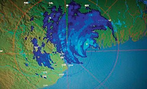
Apart from the ITR DWR, Odisha has two more Doppler radars at Paradip and Gopalpur. Sources said while the Gopalpur radar lacks clarity as the system is away from its range, now the IMD is fully dependent on the Paradip radar.
IMD Director General Mrutyunjay Mohapatra said there were initial fluctuations in the prediction as the system was unlike other previous storms. "Now it is well within the range of Paradip Doppler and as per the latest prediction, it will cross between Dhamra of Bhadrak and Bahanaga of Balasore," he added.
