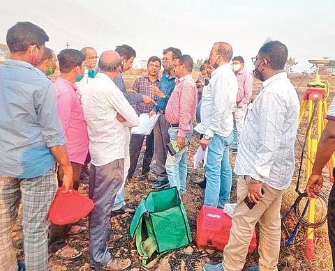
BALASORE: In a bid to resolve long-standing border disputes between Odisha and West Bengal, officials of both the states sat down at West Medinipur Circuit House to make a joint review of remote sensing maps on Thursday. Discussions were held over 36 border reference points on Odisha side and 52 in WB’s West Medinipur district, all linked to Subarnarekha river.
Basing on geo-tagging, two coordinate points were verified at Dakhin Praharajpur village close to Odisha border in presence of officials of two states to resolve the dispute. Scientists from Odisha Space Applications Centre (ORSAC) Manoj Kumar and Pramod Panda facilitated the bordering reference points through geo-tagging. The teams also visited reference points at the bordering of two states.
Officials of the two states exchanged maps to ascertain the boundary in the meeting and it was decided to hold the next meeting in Balasore in March. Both sides are verifying DGPS maps from time to time. After identifying the reference points at the inter-state boundary by ORSAC, the two states generate the coordinates where poles are installed. In this manner, so far, 36 coordinate points were identified and poles installed in 12 villages in presence of officials of both the states, Jaleswar Tehsildar Khirod Panda said.
The boundary dispute between Jaleswar tehsil in Balasore and Dantan of Paschim Medinipur district dates back to 1926 over rampant sand mining from Subarnarekha river. While the issue raged on over the years, it intensified in 2016 prompting Congress leader Sudarshan Das to petition the National Green Tribunal (NGT). The NGT directed both the State governments to take immediate measures for clear delineation of the inter-State boundary.
Governments of both Odisha and WB did not pay heed until both the parties met at Dantan in September last year and ORSAC intervened for a survey. Among others, Assistant Director of Land Records, Odisha Nigamananda Panda, Additional District Magistrate (ADM) of Balasore Sambit Nayak, West Medinipur ADM for Land Reforms Tushar Kumar Singla, Additional DLRS Arindam Mani, two section and settlement officers of WB attended the meeting.
